
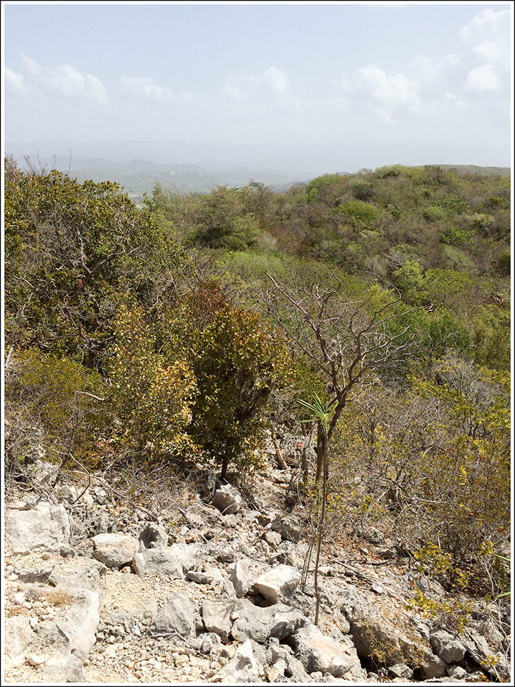
On a quick trip through Pawnee National Grasslands recently, I stopped to see the Buttes and was lucky to find some of the most dynamic and electric skies.
"What a thousand acres of Silphiums looked like when they tickled the bellies of the buffalo is a question never again to be answered, and perhaps not even asked." -Aldo Leopold
On a quick trip through Pawnee National Grasslands recently, I stopped to see the Buttes and was lucky to find some of the most dynamic and electric skies.
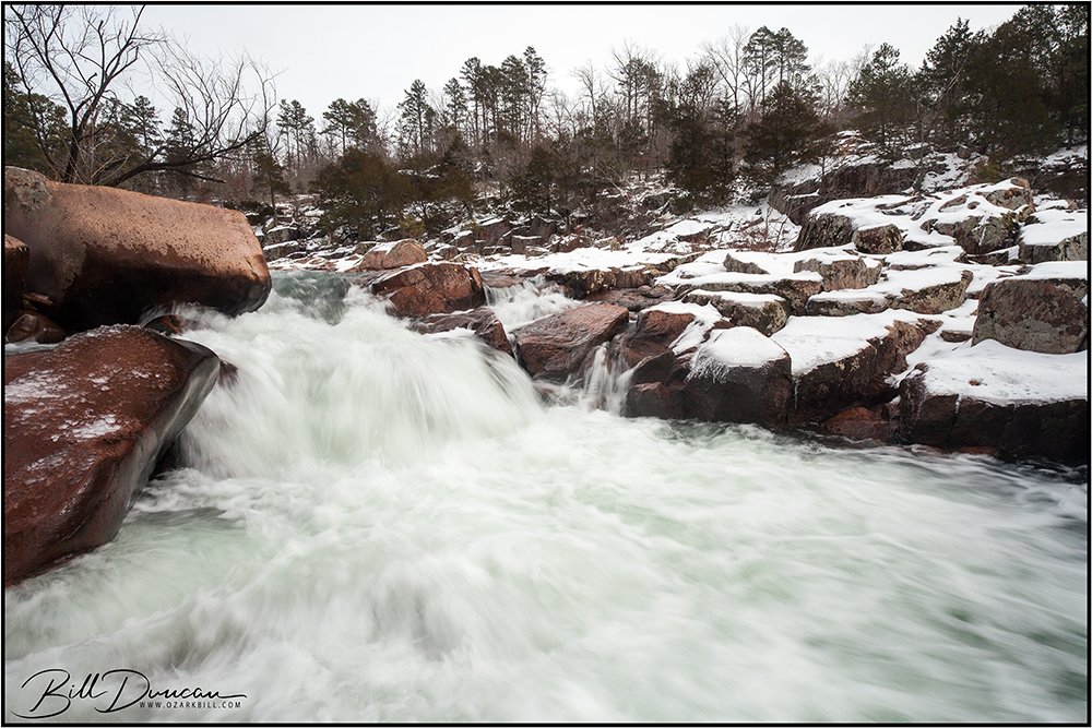
Miguel and I headed south early on Saturday morning. We arrived at Amidon Memorial Conservation Area in Madison County, MO long after first light, but early enough to get some good from what would turn out to be a very dynamic sky over most of the day. Castor River Shut-ins was our main target, as I knew we weren’t too far following some significant rainfall in the area and there was a fresh snowfall from the day before. Unfortunately, the total snow fall was nowhere near the forecast 3″-5″ that was supposed to blanket the Fredericktown/Farmington area. However, as a nature photographer knows, you take what you find.
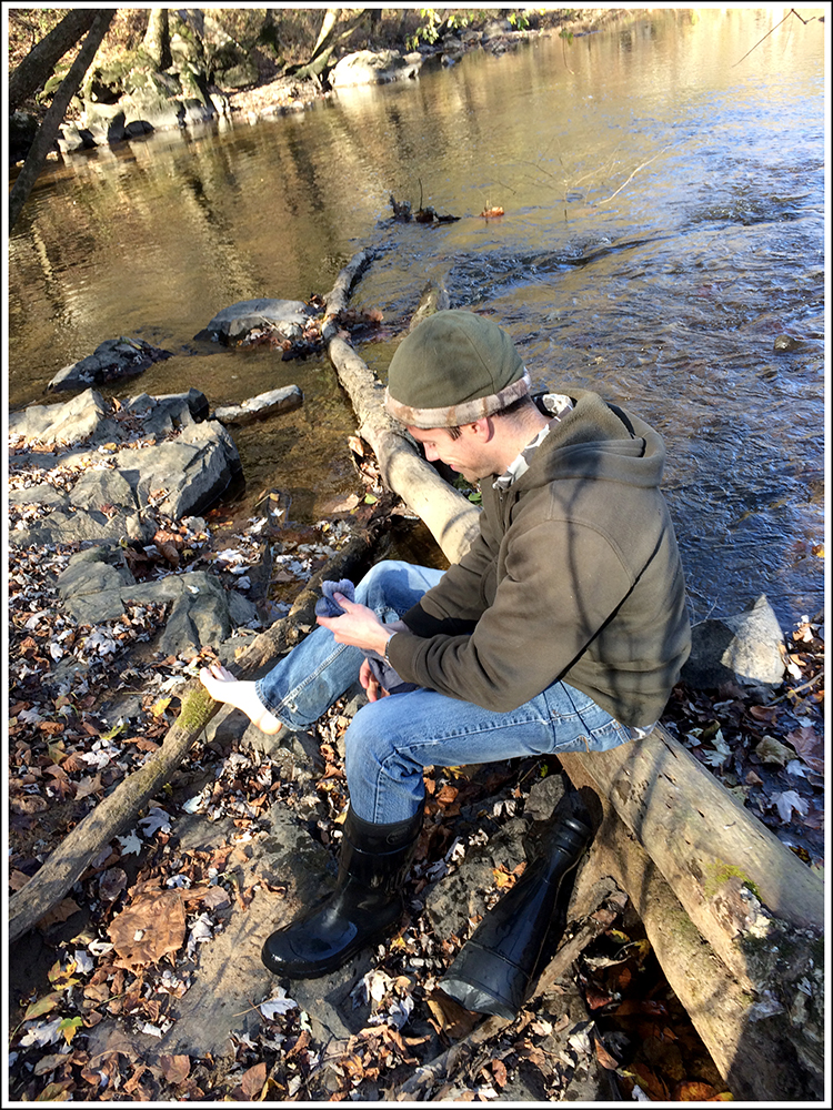
What turned out to be a very nice day of hiking and photography was nearly the complete opposite. On our way down to the river to make the above image, yours truly, normally as sure-footed as an Ozark billy goat, got one leg caught between two narrowly separated boulders while slipping with his other foot. As I went down, nearly landing on my face, I twisted my leg at just the right time and likely narrowly avoided snapping both my tibia and fibula in the caught leg. I also lost control of the tripod with the camera attached. Thankfully, most of the impact was to a small spot on the camera’s L-bracket, avoiding disaster again. Very-slight damage to the equipment and some bruising and scrapes to my leg – I will live with that when I think about the potential alternatives.
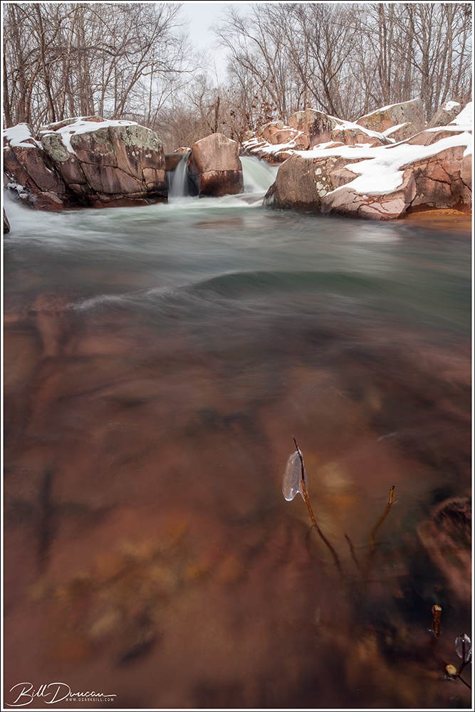
For whatever reason, I find myself drawn to vertical compositions at this location. We had nice and light cloud clover which typically provides the perfect scenario for capturing water and can make it easier to include the sky in a composition.

Here you can see Miguel hard at work nailing his composition.

I think the light yesterday was perfect in helping me avoid a problem I often have at this location, getting the color balance perfect for capturing the real colors of the rocks that make up this geological feature. Of course, those colors don’t show up the same as they do in direct sunlight.
After we had our fill at this location, still having the entire place to ourselves, we headed to Silvermines Recreation Area. Here we were primarily focused on the large defunct dam that is one of the famous features for which this location is known. We were faced with a more broken sky, but I noticed the thin cirrus/cirrostratus clouds were moving with extreme speed. Always on the lookout for a reason to use my neutral density filters, I pulled out my heaviest one and made the image below with a 30 second exposure.

Unfortunately, we weren’t in a good place and time to take advantage of a fantastic sunset. But, we made some nice images, memories and left a few calories behind on the trails.
-OZB
It has been a while since I’ve shared some photos from Wilson’s Promontory National Park, along the southern coast of Victoria, Australia. This is definitely one of my favorite places I have ever visited and today I want to tell an ecology story of a special plant that I had no idea existed until making this trip in December, 2017.

The Banksia are a highly adapted plant that are found along a number of coastal habitats surrounding Australia. Wilson’s Promontory has four recorded species, two small to medium tree type forms, Banksia serrata and B. integrifolia and two smaller brush/shrub forms, B. marginata, and B. spinalosa (1). The most abundant species on the Prom and the only one I had sense in taking photographs of is the sawbank banksia, B. serrata.
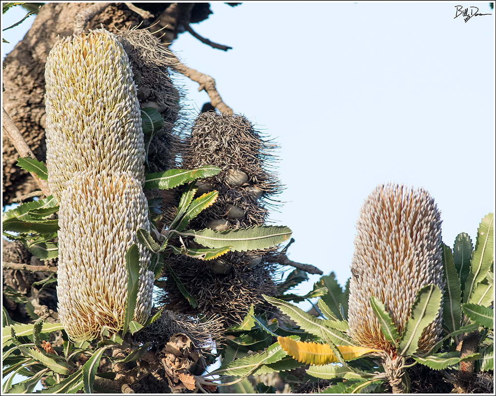
Banksia are easily identified by their bottlebrush-shaped spike inflorescence, which can contain hundred to thousands of of tiny flowers. Typically, only a few flowers will produce a hard and woody follicle that may hold the seed enclosed on the inflorescence “cone” within the canopy for as many as ten years. Although hard fires will cause the death of established Banksia, it is a necessity for most Banksia to remain stable in their habitat. Wild fire causes the woody follicles to dry and allows the opening of the hinges that releases the seeds within and promotes their germination (2).

The photo below shows a very old “cone” that is still being held on the plant despite the seed having been released due to fire-induced desiccation.

The Banksia are well-adapted to fire as the next photo attests. Collin and I found this recent cut along a trail access. The thick and furrowed bark helps to keep fire from destroying living cells underneath.

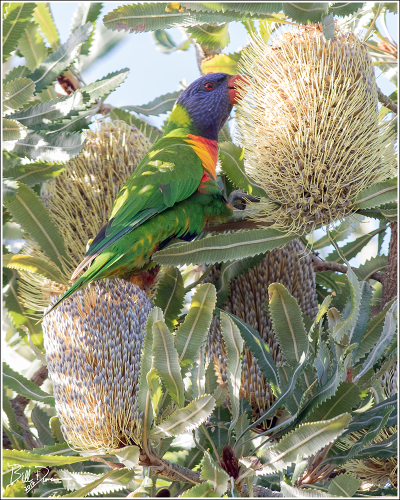
There is a great case for describing Banksia as mutualist keystone species. Nectar produced at the base of the flowers was used by original native peoples, the Gunna and the Boonwurrung, to sweeten their water. This nectar also feeds a wide variety of important insect and bird pollinators during the day and mammals, like the eastern pygmy possum, at night. Birds such as Spinebills, Wattlebirds and Lorikeets have tongues adapted with brush-like tips that helps them specialize in feeding primarily on nectar and pollen (2). The photo below shows a Rainbow Lorikeet that I was able to capture in the act of feeding.
Only the largest of seed-eating birds, like the Yellow-tailed Black-Cockatoo, can use their strong curved beaks to break into the woody seed pods of Banksia to feed on the seeds within.

B. serrata and B. integrifolia are among the tallest of trees in heathlands and similar habitats where they are found in the Prom. Because of this, they are important architecture for perching and nesting birds as well as providing shelter for small mammals. This male Fan-tailed Cuckoo is one of a few birds we found using the Banksia.

Until next time, have a good day, mate.

The Australia trip is over and I’m finally getting back to a normal sleep schedule. Our flight miles added up to nearly 21,500 miles and Collin and I drove approximately 3,400 miles in country. I have been spending lots of hours during the past few days going over the nearly 6,000 photos I took during the trip and have roughly finalized my bird list – 89 species, with a couple yet to ID from photos. Not nearly enough to match my dreams, but getting to see a bit over 10% of the continent’s birds (~850 species) while on a work trip is nothing to complain about, I guess.

On our last day in country we visited Wilson’s Promontory National Park. What an impact this place had on me. Take something like our Yosemite NP and surround it by ocean on three sides, fill it with unique habitats, exotic birds and marsupials and you have an idea of what the ‘Prom’ is like. Of course, one day was only enough to wet my appetite. Two weeks would have been better.

Entry fees for national parks in Australia vary by state. In Victoria, all NP’s are free to enter and all other states charge a very affordable rate. This makes me wonder why the cost of our parks are going through the roof and why so many state parks (not in MO) charge an entry fee. Priorities, I guess.

Here are a few of my favorite landscapes from the Prom that should give an idea of the diversity of habitats this place offers. All of these were taken less than three miles from the few roads that lie within the park.


For the first time since junior high I did not watch a single down or minute of the NFL this season and I couldn’t be happier for it. Rape my town three times, NFL – shame on you. I’ve been pleased to get those precious free minutes back for my Sundays, several of which I found I could spend not dreading the upcoming workweek.
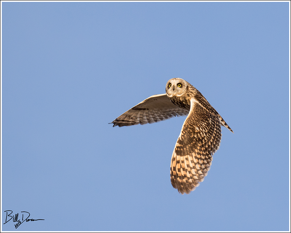
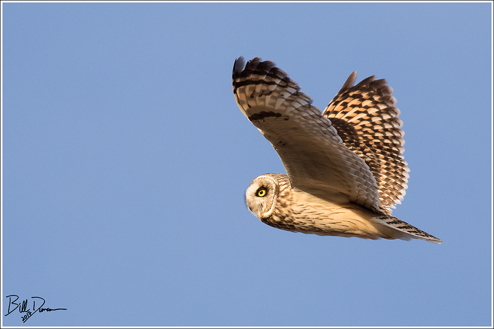
When the forecast showed a near perfect meteorological condition for shooting the Short-eared Owls of BK Leach, I figured this could be promising. While most other naked apes with functioning vision would be in front of the picture box and ingesting mass quantities of wings and beer, I would enjoy the warm and lightly breezy evening in my own kind of chair with friends of a different sort.
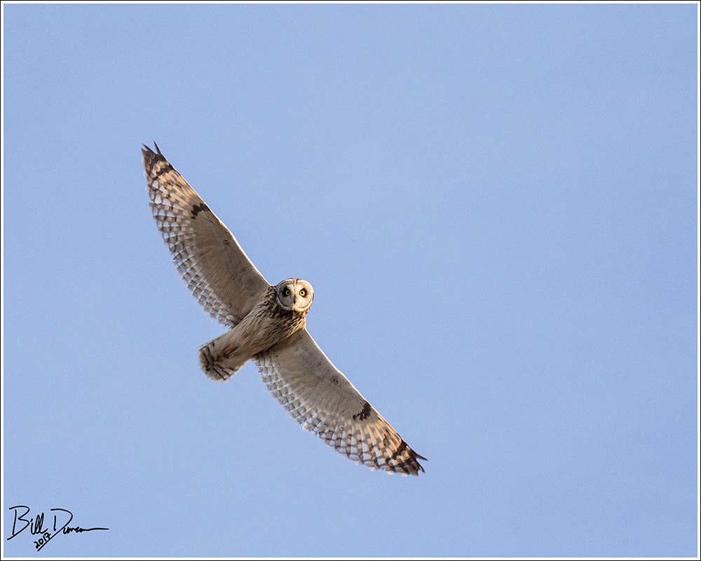
Of course there is never a sure thing. Often, when I have expected the best due to light and temperature, the owls don’t show where I set myself. On this particular day, all conditions came together and I had a super time.
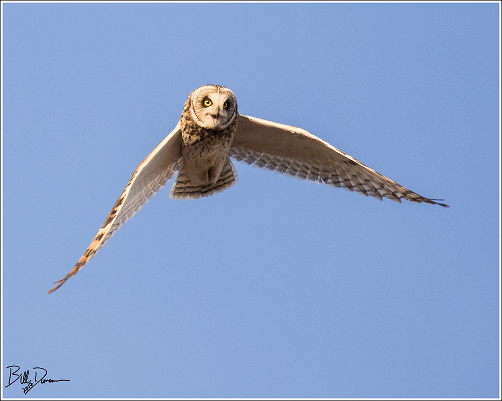
I want to give huge thanks for my lovely and talented wife, Sarah, for the special help she gave me this season in getting my best to date SEOW in flight shots.
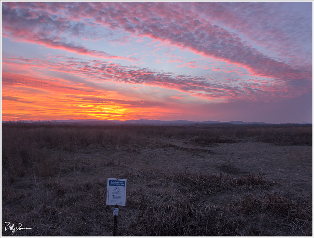
A perfect day ended in the perfect way – with a great sunset on the Lincoln Hills.
Until next time…
-OZB
“The Pinnacles are not easy to reach but a visit to the site is worth a considerable amount of time and effort. Differential weathering of vertically fractured pink porphyry created a sheer bluff cresting a hundred feet above the bed of the Little St. Francis River. Individual columns rising as monoliths above the bluff are responsible for the name, but the bluff per se is even more spectacular than the pinnacles. The site could be compared to the Palisades of the Hudson and merits photography but defies the lazy or poor planner.”
Thomas R. Beveridge
Geologic Wonders and Curiosities of Missouri
Eight different pinnacles are listed in the Legacy that Dr. Beveridge left this state. This particular pinnacles, along with associated geological features, is located in the St. Francois Mountains, just a stone’s throw away from a number of other classic destinations of this area. Steve and I had been discussing our potential route for this excursion for quite some time. We had tried once for an overland route but could not find or did not wish to aproach the private property owners and so decided that a water route was the best option for us. This past November, with leaves being mostly fallen and temperatures being much warmer than average, was the perfect opportunity to try out our designed route.
This destination lies on a stretch of the Little St. Francis River (LSF) approximately 1.5 – 2.0 miles upstream from its confluence with the St. Francis River. We knew that water levels were on the low side but we were completely uncertain what this would mean for traveling upstream into the LSF. Would there be any navigable water at all? If not, would it be possible to navigate within its bed by foot? Facing the possibility of failure, we decided to give it a shot. We loaded the canoe onto the powerful, symmetrical all wheel drive Subaru Forester and hit the road.

We dropped off Steve’s truck at our takeout – the Cedar Bottom Creek bridge and put into the St. Francis at Silver Mines Recreation Area. With the sun directly in our eyes (as almost always seems to be the case), it was a pleasant and short paddle downstream to its confluence with the LSF. See the following map for the highlighted route that we took that day.

Arriving at the confluence, our spirits were lifted. We were forced to push a little to get over a sandbar, but the route upstream was slow and just deep enough to allow for paddling most of the way. We portaged a few times, but we expected worse.
After taking in the initial views of the bluffs, we were naturally drawn to see the pinnacles themselves up close. A quick lung-burning climb and we were there.

Although not the tallest of these spires, this monolith was the more picturesque. I have other photography plans in mind for this guy if I can ever visit again. See below to see Steve in the frame for scale.

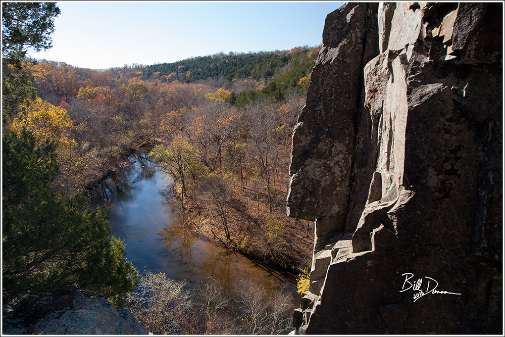
The views from atop the bluff were quite nice. The primary hill that faces south was Tin Mill Mountain and Pine Mountain lies to the north. Here is an example of the rhyolite porphyry that composes the majority of this bluff.

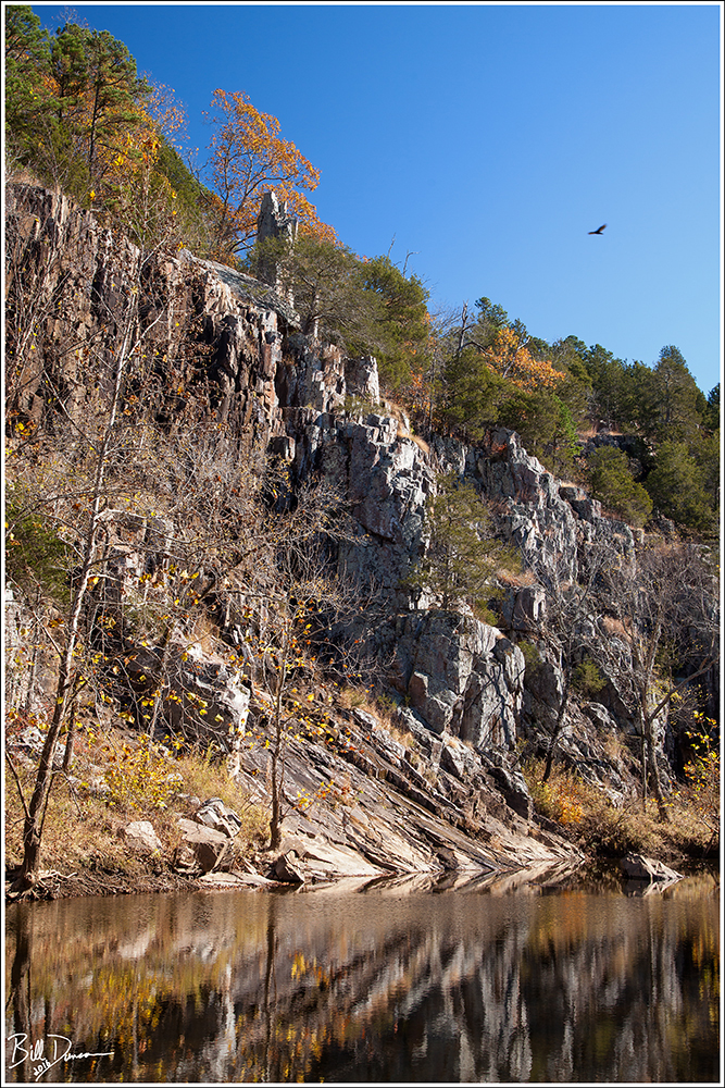
This place reminded us a lot of Lee’s Bluff, which was not surprising due to how close these locations are to one another. However, the pinnacles here brought a bit more visual interest. Here Steve poses with a small, but likely ancient cedar, clutched within a crack that is probably older than the human species.

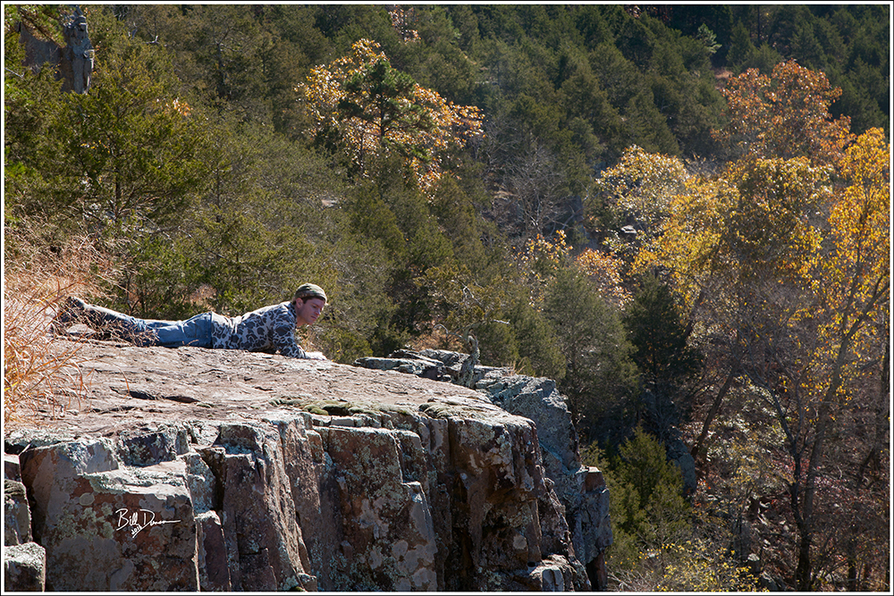
To conclude, here I captured Steve doing a belly crawl to the edge of the bluff. As I say so often, I long for another visit here. It seems the LSF has several other features to share. I hope we can one day float the entire ~15 miles with a couple or more feet of water. There are apparently a couple of stretches of shut-ins that shouldn’t be missed.
Until next time…
-OZB
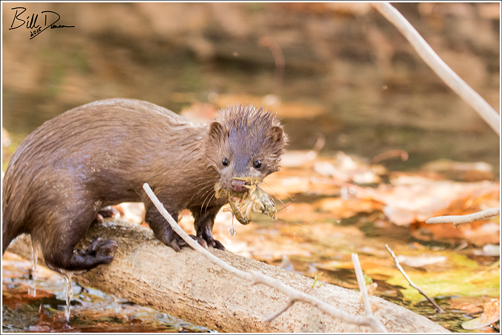
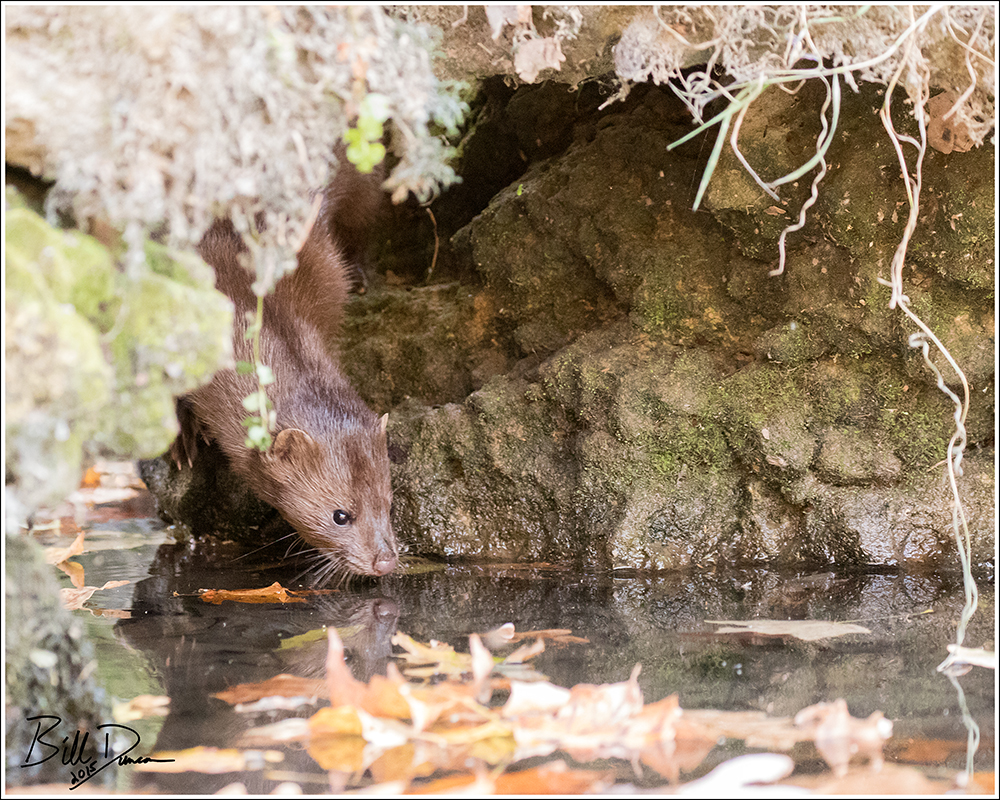
I’m finally ready to share a few more images from a float down the upper third or so of the Current River that Steve and I had the great fortune to experience this past October. We started at navigable mile 8.0 at Cedar Grove Access and pulled out three days later at mile 51, the confluence of the Current and that other, oh-so desirable, Ozark stream – the Jacks Fork. If one floats slow and quiet, the opportunity to see wildlife is very high in this National Park (Ozark National Scenic Riverways N.P.). I’v shared a couple of images of these guys previously. I believe we found 8-9 Mink during the first day of this float. It was enjoyable watching them busily hunt along the stream banks, mostly oblivious to our presence. As usual, Steve did a great job in keeping us quiet and pointed in the optimal direction for capturing some images.
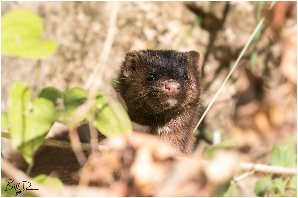
It was quite a challenge to keep up with these guys as they fished. This one below had caught a nice-sized crayfish and barely slowed to stop and enjoy his snack.
Here is a photo of one investigating the water prior to dipping back in.
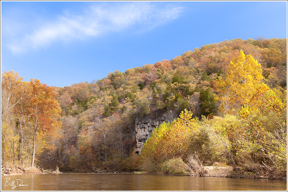
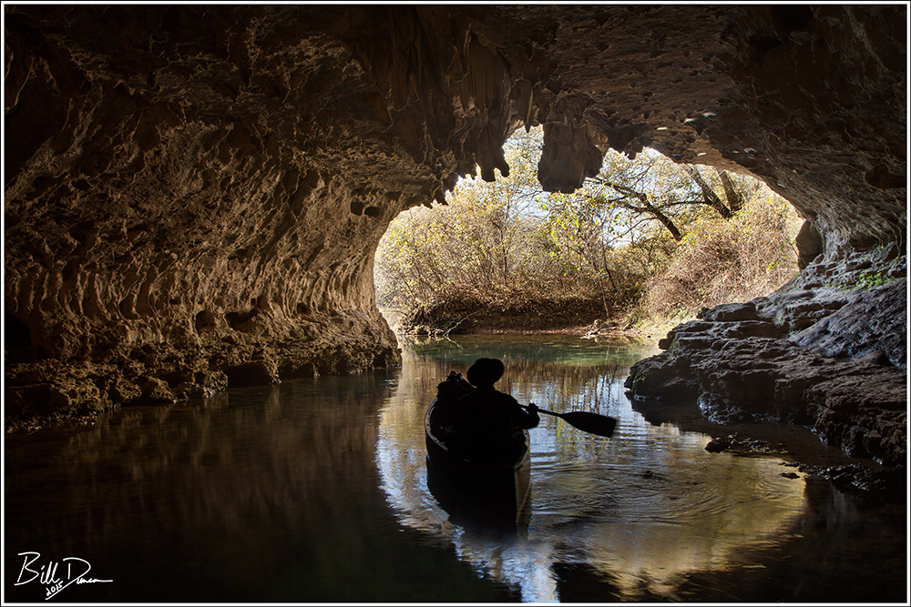
Not only does a float down the Current allow for great observations of wildlife, but many geological features are most easily seen by being on the river as well. Cave Spring can now be accessed via a nice newer trail, but it is much nicer accessing it by boat. The endpoint of a vast and interesting karst drainage system, Cave Spring rises from the back of a short cave. At the rear of this cave one can guide a boat over the vertical conduit of the spring, which is ~155 feet deep! What an eerie sensation it is to shine your light down and still see no more than a fraction of the length of the conduit shaft. In the image below, I am on a dry exposed shelf adjacent to the spring’s outlet and Steve is guiding the canoe towards the river.
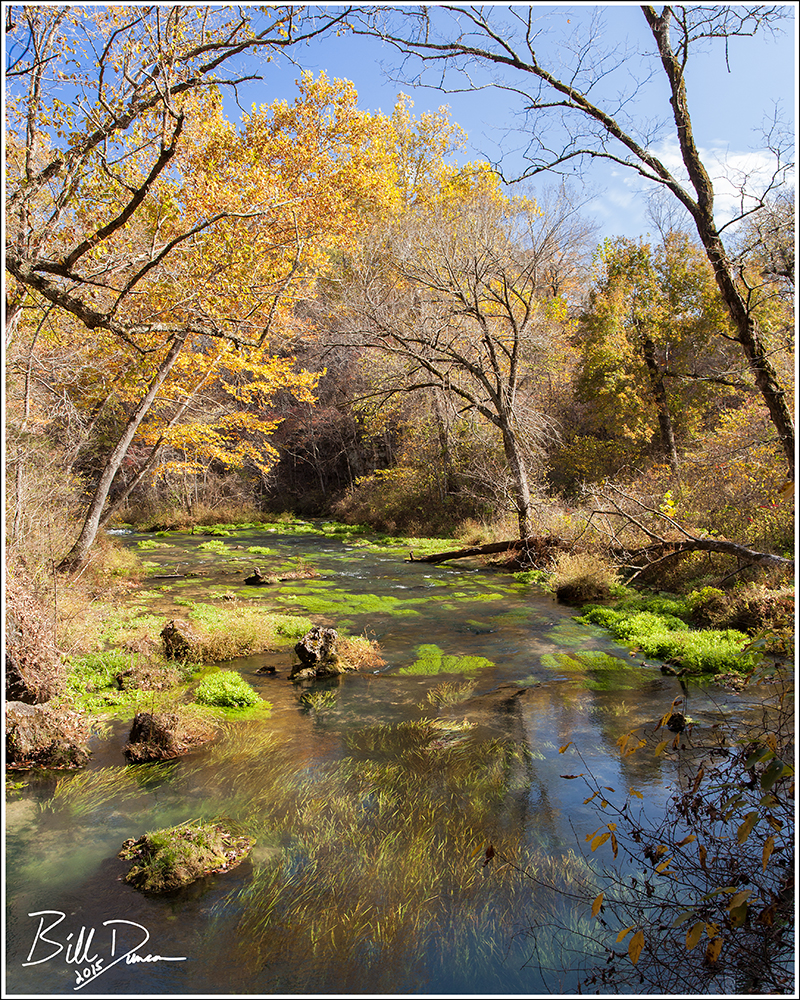
Pultite is a spring found on this upper stretch of the Current River that is surrounded on all sides except the river by private property. This means that one must boat or wade/swim to visit it. At only ~ 1/10 the output of Big Spring, Pultite is still quite a good-sized spring with and average daily output of ~ 25 million gallons. The effluent channel on this one is quite attractive and I hope to visit more often.
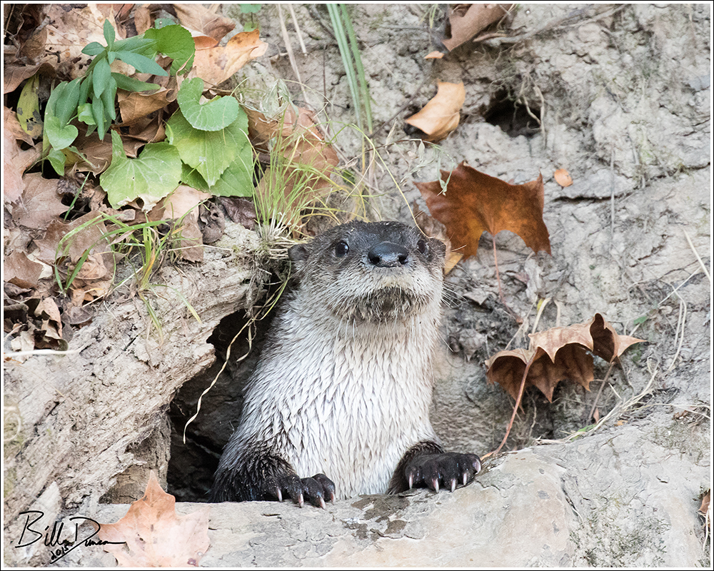
If day one was for the Mink, day two was our River Otter day. We had no Mink, but 5 or 6 of these large weasels were spotted.
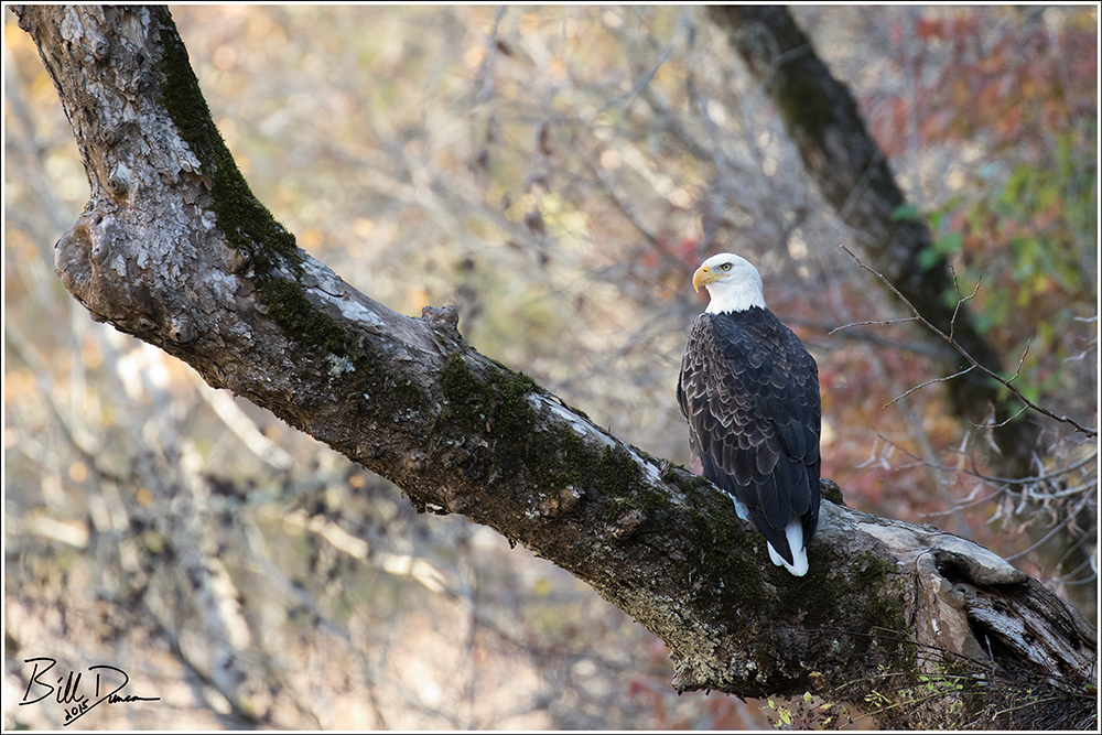
Not to forget the birds! These days, a trip to nearly any permanent Missouri water source will likely bring an encounter with a Bald Eagle. Observing these guys in the Ozarks will never get old to me.
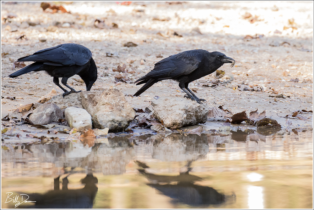
Another constant companion on these floats are the Fish Crows, here pictured finishing up a little Ozark lobster.
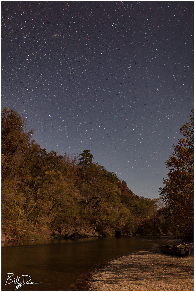
We were fortunate in having mostly clear and dry skies on this trip, which allowed us to throw our bags directly on whatever gravel bar that struck our fancy and sleep directly underneath the stars. A morning fire was necessary – not only to burn the dew off of our sleeping bags, but of course, for the river-water French-press coffee. Dark skies on these streams afford great opportunities for astrophotography. My only wish for this trip is that I was a little more tolerant of the cold, tiredness and laziness that limited my patience for getting better nightscape images… 😉
I will be posting more images of this trip on my Flickr account in the near future. Thanks for visiting and I hope to post again in the near future.
-OZB
Ask the average gringo about their perception of Puerto Rico’s climate and habitats and I am sure most would describe heavy rains associated with tropical rainforests. However, due to rain shadow effects from the central mountain chain known as the Cordillera Central, much of the southern coastal regions receive very little direct rainfall. On my first day of exploring southwestern Puerto Rico, I found myself a 20 minute drive west of Ponce in the Dry Forest of Guanica. Guanica receives about 30″ of rainfall per year, which is very close to the annual average for the state of Missouri. However, with the harsher tropical suns, coastal winds and rocky/sandy soils, this amount of precipitation does not go nearly as far in Guanica. This coastal habitat is much more dry-adapted than the comparatively lush Ozark forests of Missouri.

Typically dense and developed as Puerto Rico tends to be, the entrance to this reserve was literally on the edge of a subdivision, which is where I found myself with an hour to wait near sunrise before the gates where opened. No worries, I grabbed the camera and the binocs and did some of my first real birding on the island. With about 12 named trails of who knows how many total miles, Guanica (~10,00 acres) offers a lot to see, including a Guayacan tree estimated to be over 700 years old. The photo below shows a monument I was to see elsewhere on the island. These identification markers were carved by FDR’s Civilian Conservation Corps (“Las Tres C” in Puerto Rico). I had never given a thought about the CCC’s presence in U.S. territories like Alaska and PR, but it turns out they were quite active in PR – not only building roads and other structures but replanting forests as well. Applauds to these guys for replanting so many trees and helping to set up these reserves. However, along with the National Forest Service the CCC unfortunately participated in bringing exotic, “desirable” trees like mahogany, teak and eucalyptus. Many of these trees were chosen for their fast-growing ability and their tendencies to suck up a lot of water in order to dry out the island. Consequently, in Puerto Rico’s protected natural areas, a significant amount of the forests’ composition is Australian or Asian and completely altered.

I parked at the visitor’s center, which is located on the site of an old sugarmill ruins. I was unable to find a single trail sign. I had read the park ranger on duty spoke English, but if the attendant on this Saturday morning did, maybe he was hesitant to do so with the sweaty, ginger gringo who wielded no more than a dozen words of Spanish (see below).

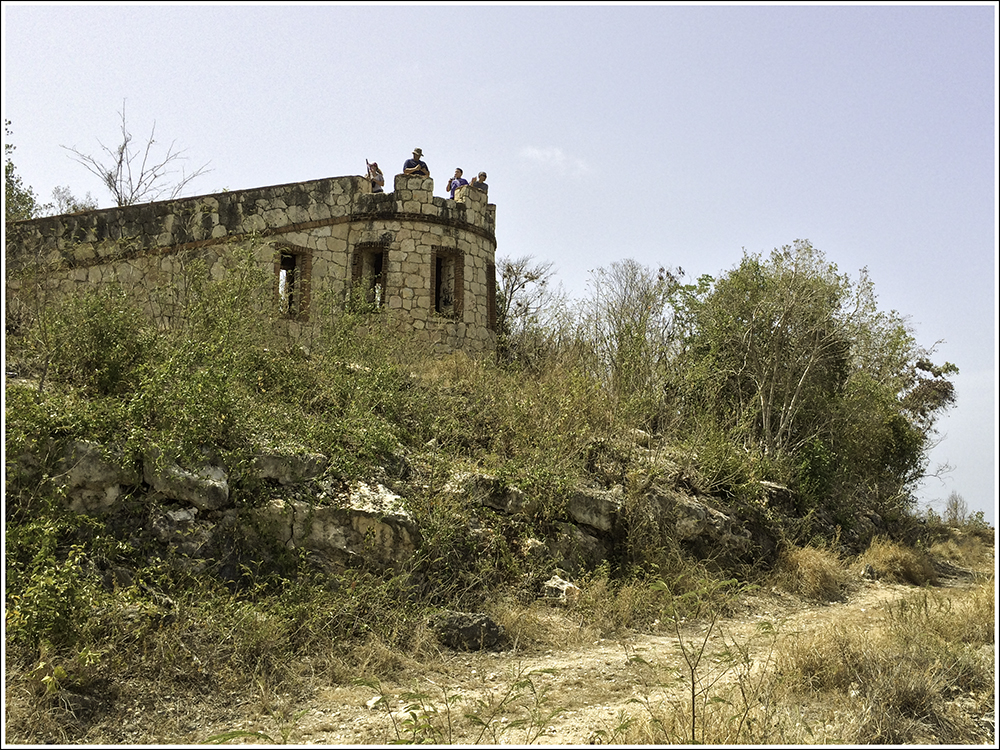
Always a good idea while out in wild areas, but definitely a good idea in PR is to use a GPS device. Every map I could find was deficient in more ways than one. The GPS unit I found to be the best during my visit was the map app on my iPhone. Also, as you might have guessed, the Guanica Dry Forest is DRY. Bring plenty of water. I thought the three liters I brought on this hike was a bit of overkill. However, at the end of my ~ eight miles of hiking up and down these coastal hills under extreme heat and sun, I was completely dry. I decided to head out on the most promising of the retired forest road trails and it wound up being the one I hoped it was, leading me to the coast where I was to find Fort Capron that was built by Americans in 1898 and is really more of a lookout tower. There is also a lighthouse nearby, but not all that interesting either.
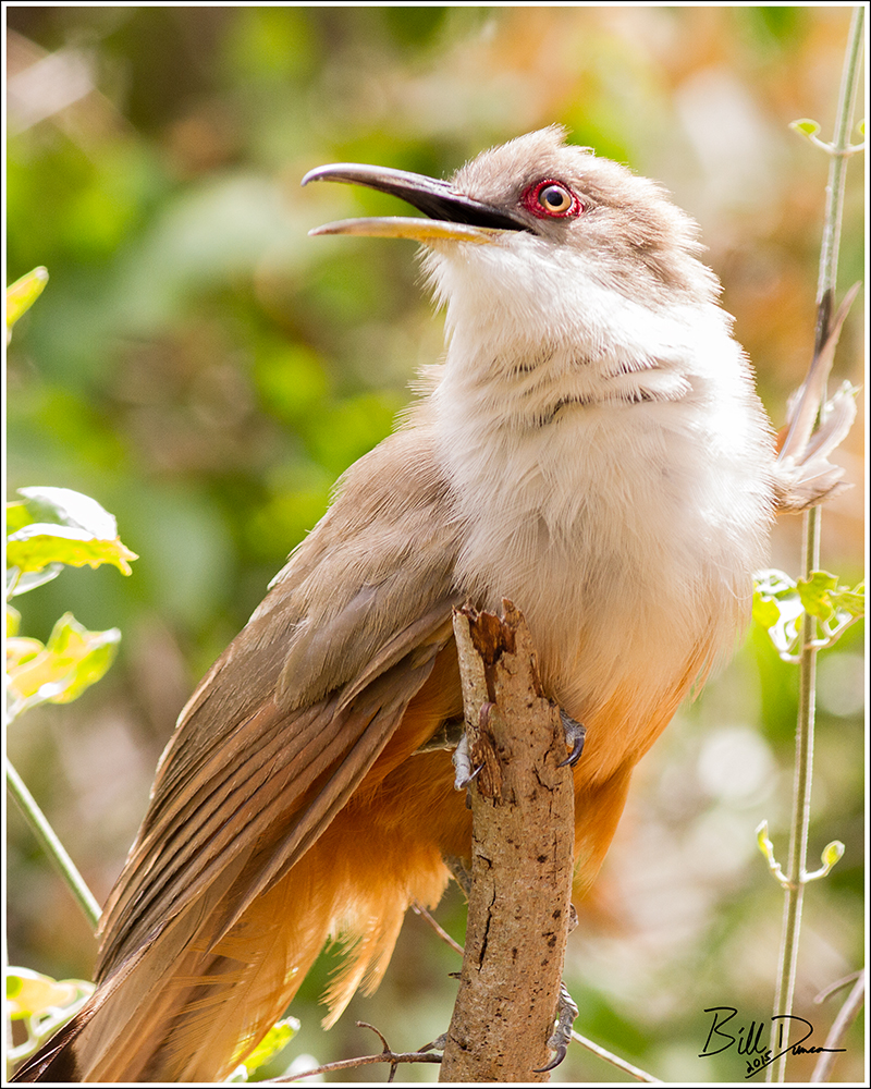
Okay, enough with the tour guide stuff. Early in the day, I made my first acquaintance with what would turn out to be my favorite bird of the trip – the Puerto Rican Tody. Check it out…

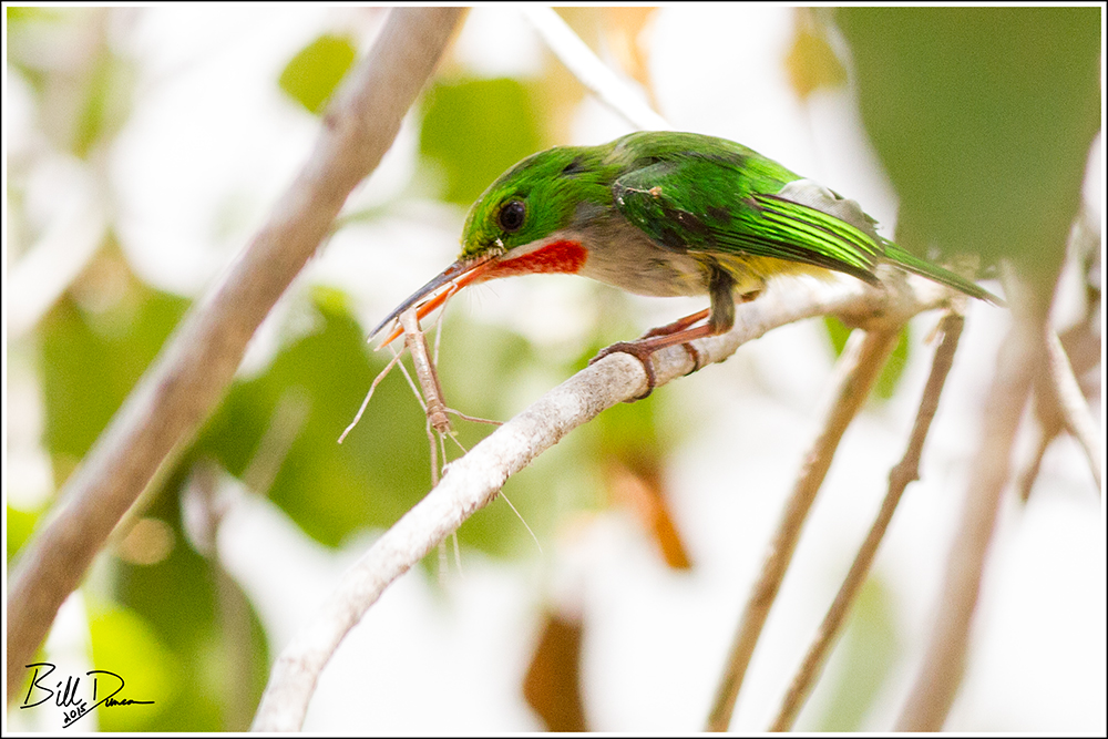
I would find these guys all over my travels in southwestern PR. They are related to and behave somewhat like the Kingfishers, are slightly larger than a Chickadee, are nearly as bold as a Kingbird and as brilliantly colored as a Parrot. I captured the one below as it tackled a stick insect.
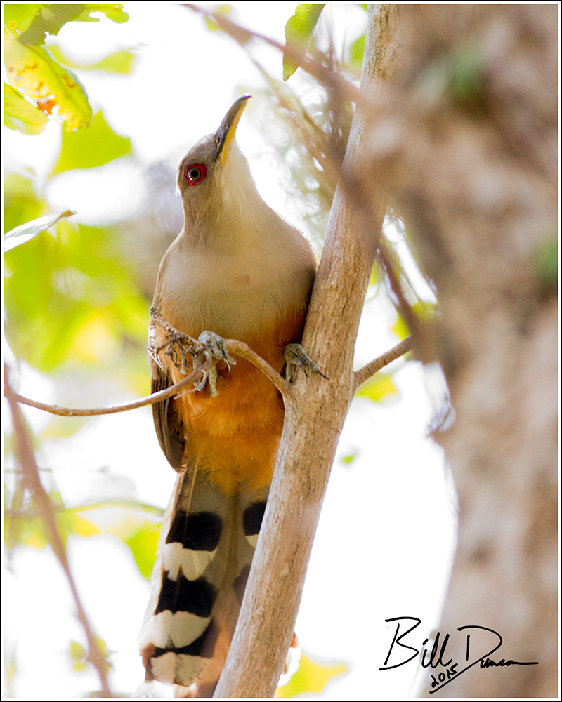
Much of the trails of Guanica are old forest roads that cut through the habitat, mostly along hilltops. Along most of my hike I was faced with thick walls of scrubby vegetation about 10- 20 feet high, often so thick that I was faced with a mere meter or two of visibility. Even though I could hear bird vocalizations, I was often at a lost to see or identify the species. With patience, however, views can be had. Near the fort, where the hillside slopes got steeper and the coast loomed near, I heard what I immediately knew to be cuckoo on their way up to intercept the trail – the Puerto Rican Lizard Cuckoo. These birds were at first so close, I couldn’t possibly get one in the frame without cutting off significant portions.
Towards this end of the reserve I was presented with more open views.
I was quite fortunate to find the quiet and shy Mangrove Cuckoo during this hike.

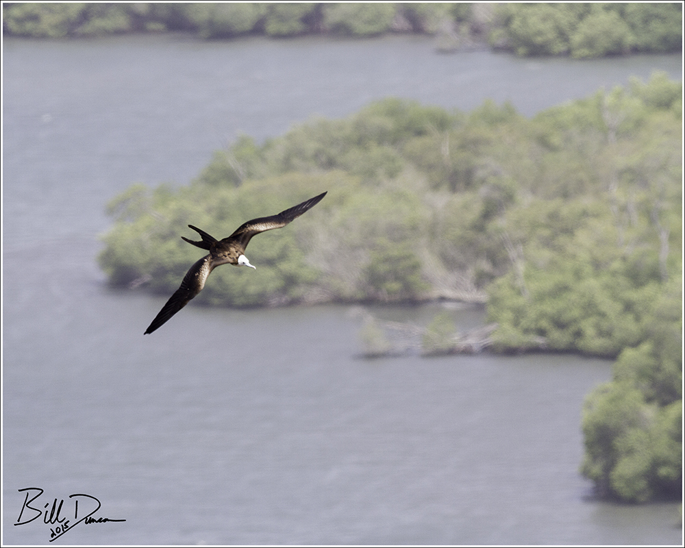
Abundant in Puerto Rico and across Caribbean coastlines, the Magnificent Frigatebird is a seabird that feeds by catching fish on the wing. This is a long-lived species. The one pictured below is a juvenile.
It seemed that the closer I was to the coast, the drier the habitat became. The Caribbean Sea is just behind me where I stood to take the picture below.

Well, that covers my trip report for the first of three days. Southwestern PR is a great place for the birder-naturalist. Of the approximately 17 or so endemic birds on the island, all but the Puerto Rican Parrot can be found here. Also, highly varied habitats can be visited within short driving distances. Stay tuned for my next day’s trip-log where I will be summarizing my day spent at Cabo Rojo NWR and Salt Flats.

If you made it this far, thanks for visiting!
OZB
A few from a trip up Black Mountain Cascades this spring.


Hello again. Although I promised myself I would get this post out on time this year, here we are on Valentine’s Day. Of course, I still have not processed everything I intend to from 2014, but I think I’ve finished the major images by now. Like last year, this is not necessarily my “best” images of the year, but a list comprised of images that captured something special to me, while being at least a competent photograph. Once again, I was nearly frozen by the list of images to choose from. I had one fewer landscape and one more wildlife image this year compared to last, for whatever that is worth. Follow the links to the posts that each image was featured in.
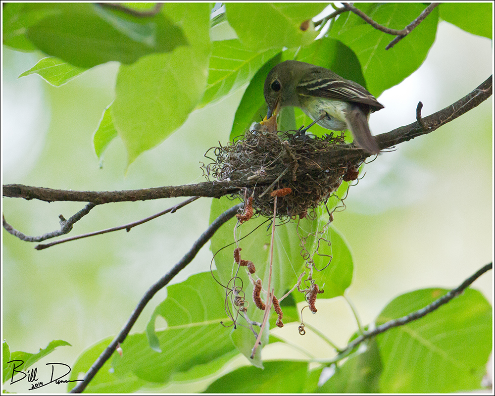
#10) “Acadian Flycatchers – Feeding Time”
Although it lacked a happy ending (see original post), Steve and I were absolutely thrilled in getting an opportunity to view and photograph a sought after nesting species. The nest location was poorly lit, being well concealed in the foliage at Hawn S.P. However, with a tripod and shutter release cable, it is something to see how slow you can take the shutter speed in these situations.
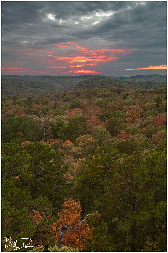
This one was from our last stay in the cabins at Big Spring S.P. for a number of years (due to closing during renovation work). It turned out to be a pretty interesting sunset, with just a couple minutes of fire.
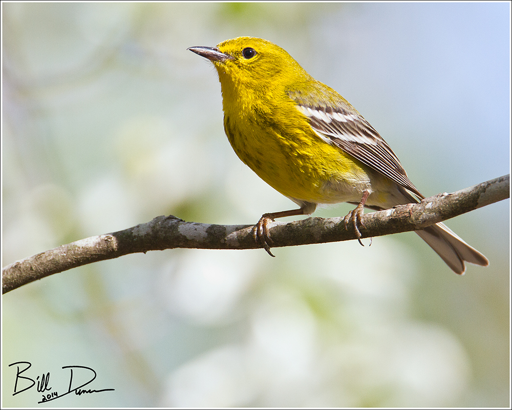
#8) “Male Pine Warbler, Big Spring State Park, April 2014”
From our vernal Big Spring trip. I was quite happy with this image, although I was hoping the white dogwood blossoms behind the bird would be a little more distinct. Oh well, always room for improvement.
From our literally unforgettable day in the canoe in the waters of Mingo. This image was taken later in the day and showcases what a sun-star pattern from a nine-bladed aperture diaphragm can look like. Kudos to Canon for putting this feature in all of their new f4 zoom “L” lenses in the past several years.

I had to place at least one image from my time in Brazil from this year. I was able to make images of quite a few species, but this patient Jacamar might be the most memorable. We came across this guy in Serra do Mar State Park in Brazil’s Atlantic Rain-forest while on a birding/nature hike. It sat while we got great views and some photographs.

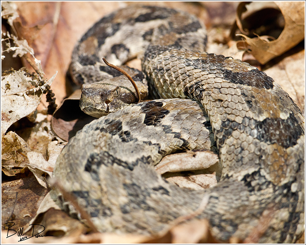
Although I questioned why I would want to bring up the memory of not having an appropriate lens to shoot snakes on “Snake Road”, I still love this image and the memories it contains of shooting this Timer Rattlesnake with a 500mm “bird lens”. Shoot, I bet most of you are thinking I did have the most appropriate lens for the job. 😉
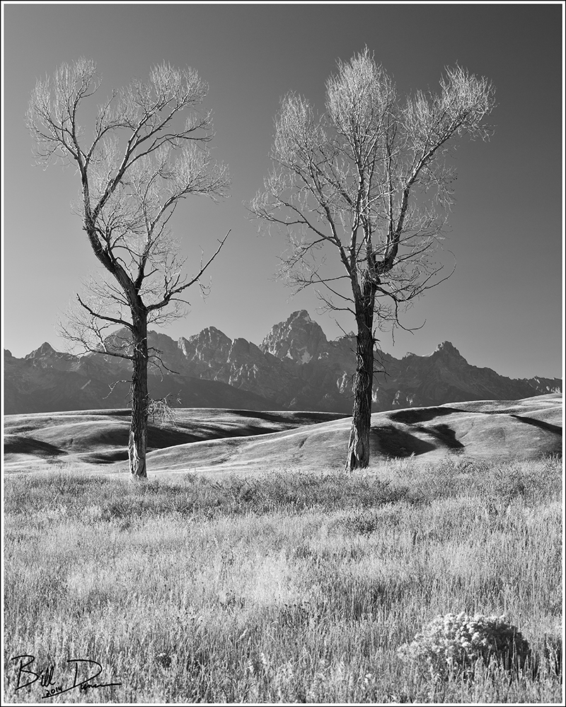
#4) “Twin Cottonwoods on Tetons”
Taken on Sarah and My trip out west this past September. This image was taken inside the National Elk Refuge. In the waning light, Sarah and I came across these two cottonwood with nicely shadowed foothills lying before the Tetons.
It’s a usable photograph of one of the rarest nesting birds in Missouri. What else is there to say? What a memory. My only regret is always forgetting that my dSLR cameras are capable of taking great video. Video of this guys singing would have been the icing on the cake.

Steve and I had two great experiences with River Otters in 2014. This one was taken on the Eleven Point this autumn and shows mom and all four of the kids in one tight shot.

#1) Bald Eagle Nest Week Three – Mom Brings a Fish
I could have picked a dozen from the weeks spent at the nest to put into my top ten. I’m not sure why I chose this one, other than it is among my favorites of hundreds of keepers from the nest. Although mom never stayed to feed the young while we were watching, she did often bring prey to the nest as is seen in this image.

Well, that summarizes a good bit of what I was fortunate enough to capture in 2014. Thanks so much to Sarah and Steve and everyone who was part of these experiences. I can’t wait to see what’s in store for 2015!
Ozark Bill Duncan – February 14th, 2015
