A Couple Autumn Days in Forest and Stream

Back in October, Steve and I had the pleasure of spending a couple days doing our favorite things in the Missouri Ozarks.  We made our base at our usual, the cabins at Big Spring SP, our last stay here for at least three years as the cabins will be closed for construction.  For our first day, we decided to take care of something that had been on my list for a number of years, to hike the largest official Wilderness Area in the state – the Irish.  Named after the Irish immigrants who settled in this area in the mid nineteenth century, the Irish was visited and pushed for protection by Aldo Leopold himself.  The Irish was finally designated by law as an official wilderness area in 1984 after close to two decades of work by a number of caring people.  This area was virtually cleared of its timber by the early years of the 1900s, but was replanted with its current deciduous hardwood mix by the CCC in the 1930s.

Ozark Bill in the Irish

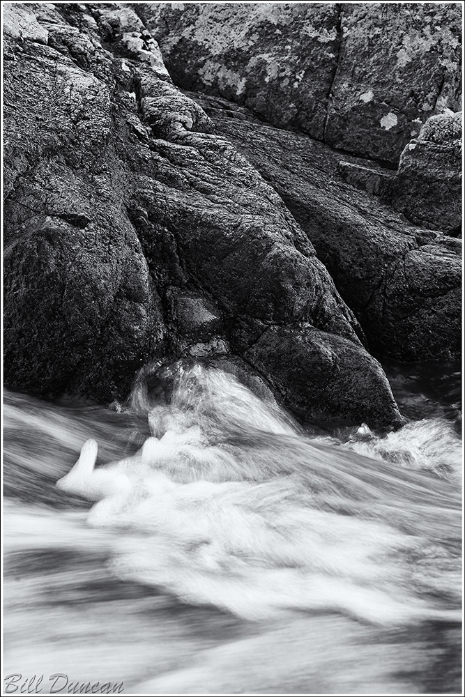
Officially listed as 18.4 miles, the Irish Wilderness loop trail is typically tackled with a night or two of backpacking.  Being the athletic super-freaks that we are, Steve and I put down an estimated 22 miles, with some back tracking and assisting a lost backpacker (a GPS unit with topographic map display is quite the asset here), in about 16 hours.  It would have been more enjoyable with a night or two sleeping in the woods and spending more time, but we had other plans in store as well.  The image below is from an overlook of the Eleven Point River at close to the halfway point of the hike.  I will never forget standing here in the late afternoon light with hundreds of ladybird beetles covered the rocks and filled the air.

The Eleven Point
The Eleven Point

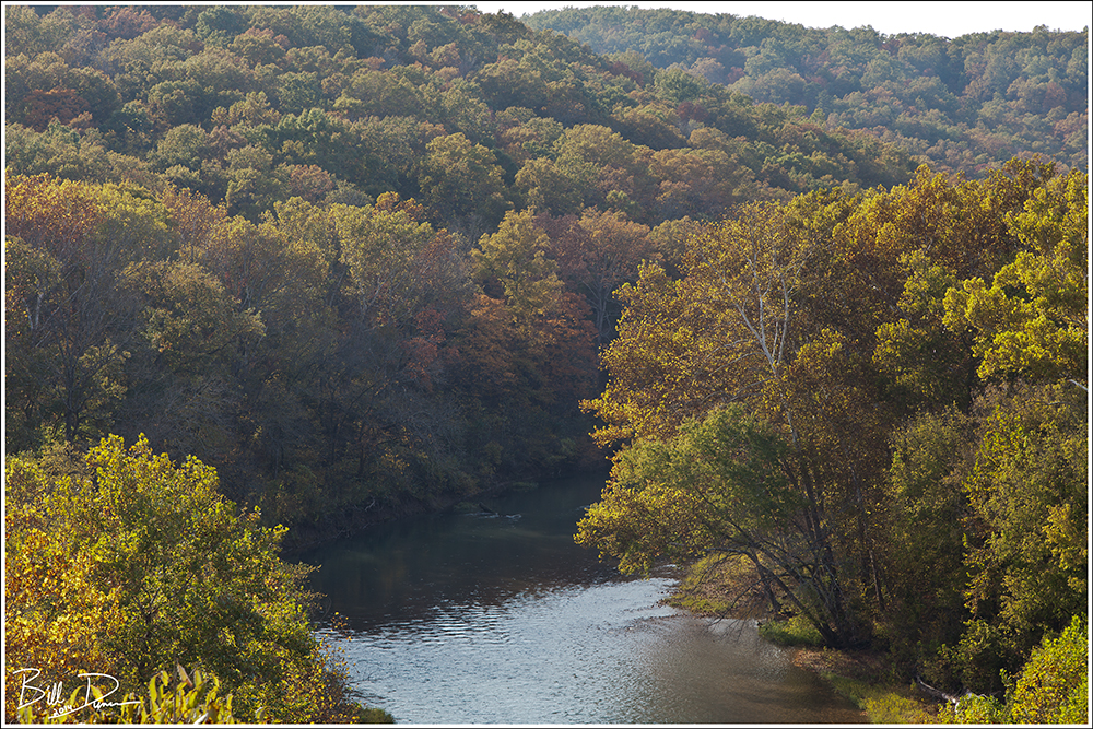
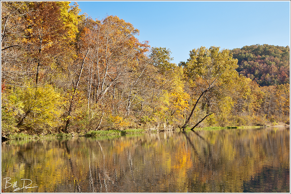
Covering 20 miles in a single day does not leave much time for taking photos.  After getting some much appreciated sleep back at the cabin, we arose early to arrive at Richard’s Canoes to be in the water by ~07:30.  We put in at Greer Spring Access (mile 16.6) and had the day to move the ~12 miles to our take out at Whiten Access (mile 27.6).  The Eleven Point offers a perfect mix of slower moving stretches and deep pools mixed with just enough class 2 rapids to keep things interesting.  Make sure to bring along some wet bags if carrying delicate camera or other electronic equipment.  We were offered autumn views like this around nearly every bend.

IMG_2484
Autumn on the Eleven Point

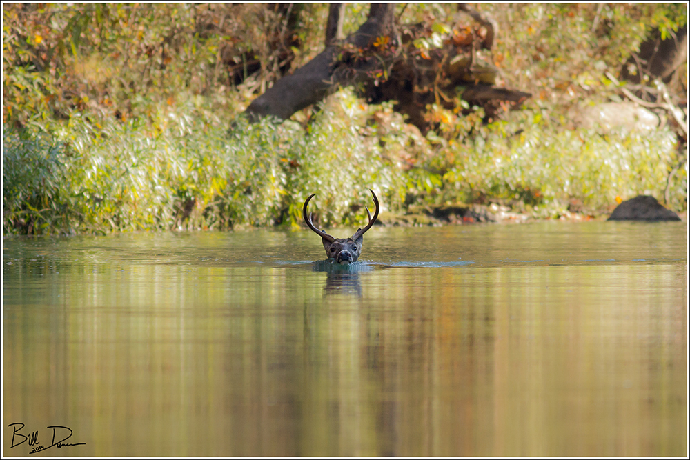
As if the landscape and feelings of being on the river were not enough, the wildlife opportunity are surely the highlights for a float trip like this, assuming you are quite and keep your eyes open.  This White-tailed buck was moving upstream when Steve spotted him.

Swimming Buck
Swimming Buck

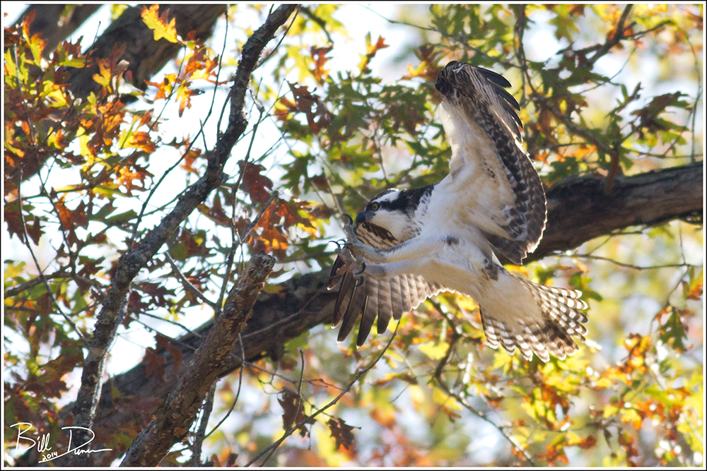
Of course the birds will be abundant along any Missouri Ozark stream at any time of year.  We were thrilled to see this Osprey come in to perch nearby as we floated.

Osprey
Osprey

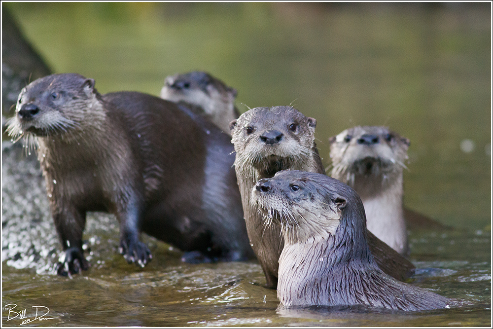
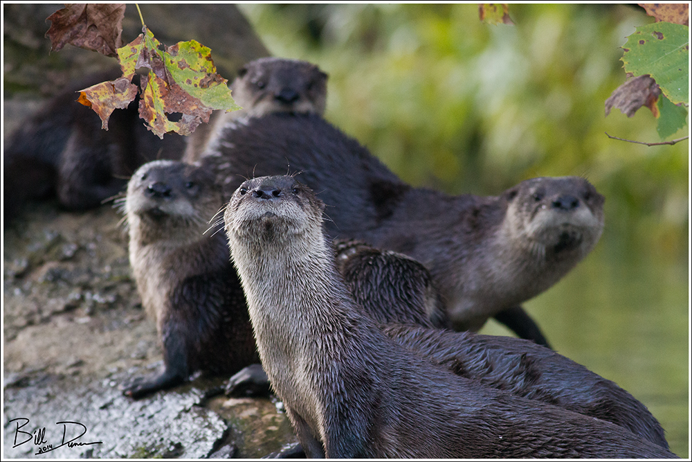
Within a couple of miles from our take-out point, we were presented with our pièce de résistance for the float, two groups of River Otters!  The images below are the first group, a mom and four pups.  These animals were venturing out of their den to play in the day’s last light.

IMG_8215
Three Pups

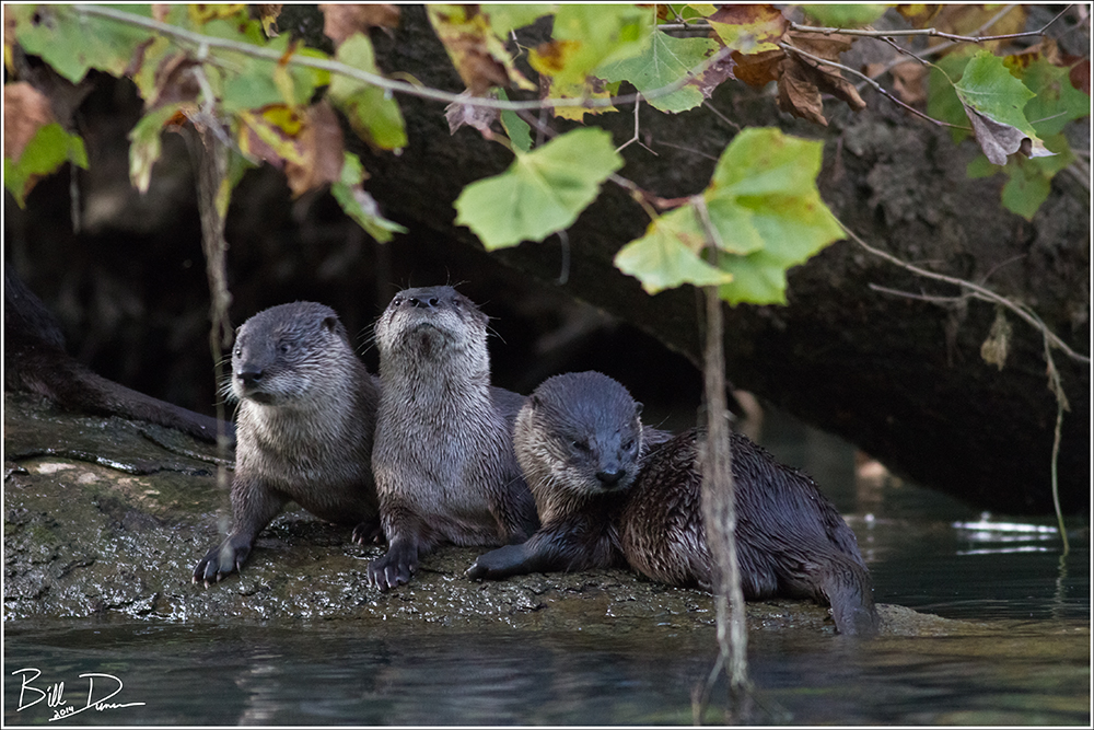
The pups seemed not too concerned, but mom kept a close eye on the floating log with ugly heads.

Otter Family
Otter Family
Otter Family II
Otter Family II

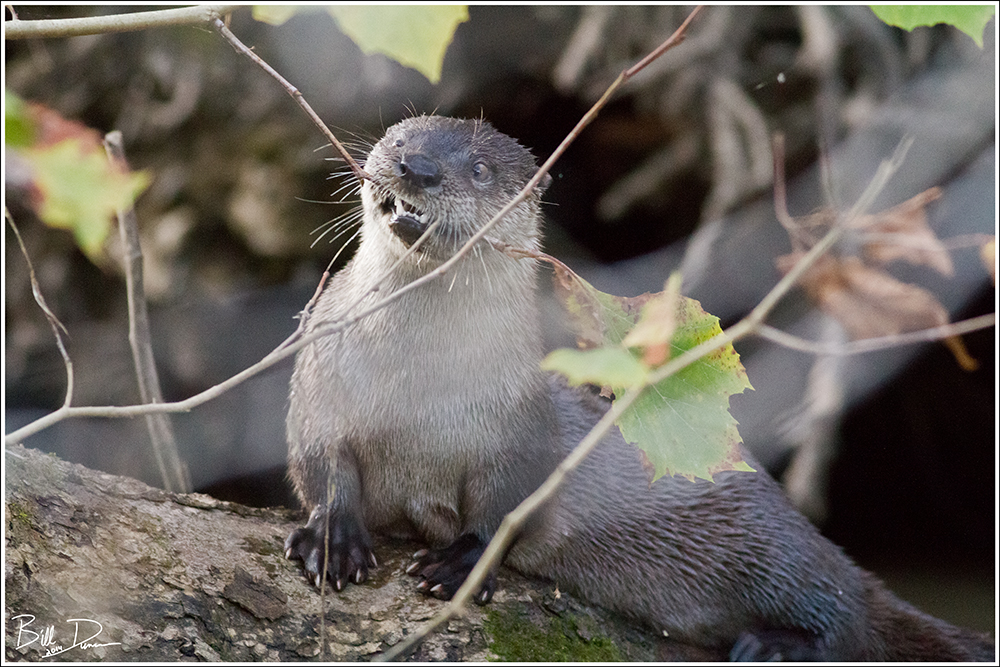
These guys will turn anything into a toy… 😉

Playing with a Twig...
Playing with a Twig…

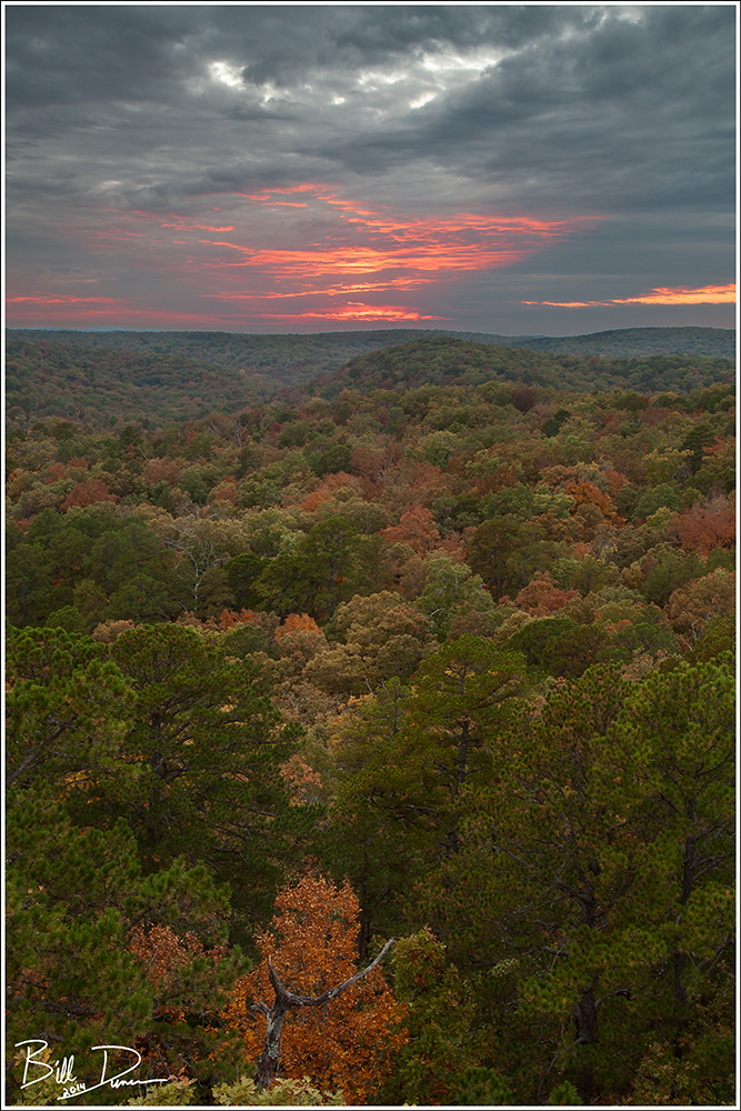
I leave you with a sunset from the nearby Big Spring State Park and eternal thanks to those who worked so hard against heavy opposite forces so that, at a minimum, we have what we have today.

The day is almost upon us when canoe travel will consist in paddling up the noisy wake of a motor launch and portaging through the back yard of a summer cottage.  When that day comes canoe travel will be dead, and dead too will be a part of our Americanism…

-Aldo Leopold-

Wild Horizons
Wild Horizons


A Hike Down Rocky Creek

I have been wanting to make the hike down Rocky Creek to its confluence with the Current since I read about the idea in Louis C. White’s Ozark Hideways.  This past Saturday, Steve and I were both aching to get on the trails, to be with nature on a beautiful late winter’s day.  This hike was high on the ever-growing list of potential day-hikes, so we decided that this was the day for this one.  As was the plan, we started at the Rocky Falls N.A. parking lot.  We found that the water level in Rocky Creek was a bit higher than we expected.  While this is fantastic if your goal is to get some nice flowing water shots, it can make for some wetter than desired hiking and stream crossing.  Although this stream is not officially in the St. Francois Mountains, the exposed red rhyolite reminds me of the scenery there to the north-east.  We would see three of the best shut-in areas to be found in the Missouri Ozarks, with Rocky Creek Falls being first.  This image was taken on a previous visit.

Rocky Falls

“Rocky Creek Falls″

Technical details: Canon EOS 50D camera, EF17-40mm f/4L USM @ 23mm, ISO 100,  f/16, 1/4 sec

The first half mile or so of the hike is spent walking alongside the creek, past an impressive beaver-pond until this little side-spur hooks into the Ozark Trail.  A right turn leads to Stegall Mountain, one of the “higher” peaks in Missouri and Peck Ranch C.A.  We turned left to keep along with Rocky Creek and head ultimately to the Current River.  The OZT comes and goes from within sight of the stream.  When possible, Steve and I strayed from the trail and kept close to the stream.  About a half mile from the Hwy NN crossing, we came across the next series of major shut-ins, those at the base of Buzzard Mountain.  The photo below was made on a previous visit.

Buzzard Mountain Shut-ins

“Buzzard Mountain Shut-Ins″

Technical details: Canon EOS 50D camera, EF17-40mm f/4L USM @ 22mm, ISO 250,  f/14, 1/20 sec

Continuing past these beautiful formations of rock vs. water we followed the stream.  It was difficult to make progress, as around every bend there were shelves of exposed, upraised porphyry.  These ~ 3.5 billion year old “benches” were perfect traps for lounging and loafing, snacking and passing the time philosophizing, all the while listening to the ever present sounds of the crystal-clear water fighting its endless battle downstream.  This image was made in between our breaks.

IMG_3052

“Another World″

Technical details: Canon EOS 5D Mark II camera, Sigma 15mm f/2.8 EX DG, ISO 100,  f/14, manual blend of two exposures

A mile or two past Buzzard Mountain we came across the third and last of the major shut-ins along Rocky Creek.  These shut-ins are at the base of Mill Mountain, and the Klepzig Mill can still be found here.  Somehow, after several visits I have still not photographed the mill structure.  Oh well, another excuse to return.  Below is a photo of the shut-ins made on a prior visit to the area.


“Mill Mountain Shut-Ins″

Technical details: Canon EOS 50D camera, EF17-40mm f/4L USM @ 24mm, ISO 250,  f/16, 1/25 sec

About here we left the OZT to continue east with the stream towards its rendezvous with the Current.  The vast majority of the course of the stream has a very shallow base; in most places it can be forded without wetting your knees.  Once in awhile, pools deep enough to swim in would come about.  These pools held some decent sized fish and looked quite inviting for a swim.  Near one of these we stopped for a bite, including some tuna sandwiches that Steve brought along.  At one point Steve missed his mouth and a chunk of tuna  landed in the water along a shallow shelf.  We watched to see if a fish would come along for a free bite.  No fish found this piece, but in a few minutes this guy, smelling the oils leaching from the fish presumably, came out of the depths to scavenge our waste.

IMG_3115

“Spothanded Crayfish″

Technical details: Canon EOS 5D Mark II camera, EF100mm f/2.8L Macro IS USM, ISO 400,  f/4, 1/60 sec

Did you know…? The Missouri Ozarks are home to 25 species of Crayfish, seven of which are found nowhere else.  The ancient geology of the Ozark region has created spatially isolated streams, supporting varied aquatic habitats based on bedrock and erosional composition.  This has enabled high speciation rates of crayfish and other aquatic and riparian animals.

The Spothanded Crayfish is known to have specific color and other morphological differences between populations in Missouri.  In the western populations, such as this one found in the Current River watershed, the species is greenish in color and contains the dark spots  on the base of the pincers, while populations in the eastern drainages of the Meramec and Black Rivers usually do not show the spots and have red or orange tinted pincers.

Read more about the Spothanded Crayfish or any other of Missouri’s Crayfish by checking out this wonderful guide: The Crayfishes of Missouri, by William Pflieger.

Another two or three miles of stream-side bushwhacking, trail and forest road hiking and we found ourselves at the confluence, the now flat and tranquil Rocky Creek dumping its waters into the Current River.  The hike back was quicker and partially under the cover of darkness.  A highlight of our return was very close looks of an American Woodcock that we heard wobbling  among the dry leaves near the trail.  A favorite of mine.

We finished the day by grabbing a couple of pies at Saso’s in nearby Ellington.  The pies were fine, but no homemade baklava was on hand… 😦

I’ll end with the late-afternoon view we had from the point of the confluence.  Rocky Creek is moving in from the right.  The sun was pushing its last of the day onto the hills and was partially obscured by rapidly-moving clouds.  This resulted in the dynamic light across the landscape on the opposite bank of the Current.  I decided to go with a bit of a pictorialist treatment, but I am not completely convinced it was the best direction to go.  I used the clarity slider in ACR RAW to give the image a softer, less defined appearance, hopefully bringing attention to the changing tones as well as to the calmness of the water, which is juxtaposed by the images made upstream that were placed earlier in this post.

Well, I hope this wasn’t boring, and perhaps makes you wish to witness some of these locations for yourself.  Until next time, make like a camper and go take a hike.

IMG_3139


“A Place in My Heart″

Technical details: Canon EOS 5D Mark II camera, EF24-105mm f/4L IS USM @ 96mm, ISO 125,  f/10, 1/13 sec

A Warm Winter’s Day in the St. Francois

With forecasted highs near 60F, there was no question what I would be doing this past Saturday.  The only problem was where to take a hike!  Being mid-January and a warm, sunny day, I knew that Lower Rock Creek would not disappoint.  As expected, the Ozark Witch Hazel was in full bloom and beautifully fragrant.  The sky was completely clear and the lighting harsh for much photography of the many water features the area has to offer, but of course I had to try.  Ultimately I just tried to enjoy the hike and experience the wilderness that life continually rips from my fingertips.  There were a good number of ice formations still left on north-facing canyon walls and this particular patch was beginning to melt, releasing its maker into a mirror-like pool that ultimately fell down this drop and married with the rest of the stream.  I looked for ways to get closer to these formations but could not find a safe passage.

IMG_2548

Technical details: Canon EOS 5D Mark II camera, EF17-40mm f/4L USM @ 40mm, ISO 200,  f/11, manual blend of two exposures

On the way upstream, I stayed off the trail as much as possible; I preferred following the creek bed although wet and icy rocks often made this a challenge.  A couple of times near bends I was forced to go up and over a ridge because of lack of good foot or handholds above the creek.  After about three hours of rock hopping with my 30lb pack, fatigue started to creep in and I twisted my ankle bad enough to cause a minor sprain/strain.  This was very close to this wonderful swimming hole, so I pulled my boot and sock off and dunked my foot into this spring-fed water… for about 30 seconds.

 IMG_2551

 Technical details: Canon EOS 5D Mark II camera, EF17-40mm f/4L USM @ 25mm, ISO 100,  f/11, manual blend of two exposures

 On the way back downstream I followed the trail most of the way, shedding layers as the temperature rose over 5oF.  Along the route I was fortunate to spot a coupling couple of Eastern Garter Snakes.  These light-bodied snakes, much like grasshoppers and Morning Cloak Butterflies, will often wake up and see what’s happening on a warm winter day.  And usually, the males have something other than food in mind.  As can be seen in this image, the female was about two thirds larger than her mate.  Following a successful copulation, the female can store sperm until closer to the warmer months, and many snake species can and do copulate several times and will actively select sperm of her choosing.  I tried my best not to disturb this pair too much.  They were rather laid back and didn’t seem to be alarmed, even when I lowered the diffuser mere inches from them.  When I left the male was still busily making his intentions known, while she kept her eye and tongue focused in my direction.

IMG_2597

Technical details: Canon EOS 5D Mark II camera, EF100mm f/2.8L Macro IS USM, ISO 400,  f/11, 1/40 sec

 After having some lunch at the car I tried my best at finding the John James Audubon Trail that I have been wanting to visit for a while.  After some fruitless searching I was unable to find a single trail-head, placard, sign or blaze marker that I was confident in.  Unless I hear otherwise I will consider this a defunct trail.  So I decided to visit the Castor River Shut-ins and spend the remainder of the daylight hopping around on even more rocks.  The lighting was still rather poor and I had little inspiration for finding a composition so I experimented a bit, focusing on the effect of minute changes in exposure time on capturing the movement of flowing waters.

IMG_2651

 Technical details: Canon EOS 5D Mark II camera, EF24-105mm f/4L IS USM @ 60mm, ISO 320,  f/7.1, 1/13 sec

IMG_2789

Technical details: Canon EOS 5D Mark II camera, EF24-105mm f/4L IS USM @ 80mm, ISO 400,  f/6.3, 1/40 sec

Bell Mountain Willderness Loop Trail – Success!

Surprisingly, I found myself in the St. Francois Mountains again yesterday.  I decided to finally attempt the full loop trail within Bell Mountain Wilderness.  I have hiked to the summit and back the same way several times over the past five years or so, a hike that is approximately ten miles.  The loop requires you go down the other side, follow and cross “Joe’s Creek” and its feeder streams along the way and then ascend Bell once again before going back down to the southern trail head.  It wound up being just short of a 13 mile trek.

“St. Francois Mountains – Late Autumn – 2012″
Technical details: Canon EOS 5D Mark II camera, EF70-200mm f/4L IS USM @ 127mm, ISO 100,  f/16, 1/10 sec

An “Indian Summer” kind of weekend assured I was not the only one with the idea of hiking this summit.  Normally a place where you would be unlikely to see another person, I crossed paths with close to 40 hikers, most of which seemed to be carrying camping gear.  I started the the trail promptly at 8:00 when the temperature was still pleasantly in the low 50s.  Unfortunately when I arrived back at my car  around 2:00 the temp was in the mid 70s, a bit on the warm side for hiking such a challenging trail.

“The Burning Bush″
Technical details: Canon EOS 50D camera, EF17-40mm f/4L USM @ 26mm, ISO 160,  f/18, 0.4 sec

The images above and below this text showcase what makes this area so special – the Ozark glades.  These pinkish, lichen-covered, rhyolite/granite boulders protrude from thin soils and create igneous glades.  This specific habitat is associated with several specialized plant and animal species.  In periods of hot and dry weather these areas seem completely abandoned, but will come alive following a drenching rain.  The image posted below was subjected to a “hand-painted” treatment in computer post-processing.

“Changes″
Technical details: Canon EOS 50D camera, EF17-40mm f/4L USM @ 28mm, ISO 100,  f/11, 0.25 sec

The image below this text documents a perplexing problem with officially designated wilderness areas.  As the law was written, no human management of the land, of any kind, can be performed.  While this law includes items you want a “wilderness” to be protected from, building of structures, new roads, logging and grazing, etc., it also includes management for the protection of habitats.  Although glades exist primarily due to shallow soils and dry, higher elevations, periodic fires also play a key role in limiting the succession of habitat type.  Fires, both natural and anthropogenic in origin, played a key role in controlling secondary succession shrubby tree species such as sumac, sassafras, and especially the eastern cedars.  In many well-managed lands across the Ozarks, prescribed fires are doing their part to control this succession and preserve these habitats.  On wilderness areas, prescribed fires are not legal.  Modern fire-prevention in private and public lands also drastically reduces the occurrence of natural fire.  The glades on Bell Mountain and its nearby slopes are all being choked by eastern cedars.  Given enough time this potentially put many Ozark glade areas at risk as the succession continues to include various oak and hickory species.

“Bell Mountain Glade in Autumn″
Technical details: Canon EOS 50D camera, EF17-40mm f/4L USM @ 26mm, ISO 100,  f/16, 1/8 sec

Bell Mountain is bordered by Shut-In Creek on the east, which has helped carve the distinction between Bell Mountain and nearby Lindsey Mountain.  This creek bottom is a short, but extremely sharp drop from the summit, and the creek is a perennial spring-fed water source.  Joe’s Creek borders the western side of Bell Mountain and is also partially spring-fed.  These two bodies provide many a backpacker with a source of water.  I can’t wait to try exploring this creek after a good wet period.

“Shut-In Creek Bottom″
Technical details: Canon EOS 50D camera, EF-S60mm f/2.8 Macro USM, ISO 200,  f/16, 1/4 sec