The Gulf

Pulled from Beveridge’s gift early after my discovery of the book, “The Gulf” of Wayne County has been on my list of desired destinations for a while now.  Recently Steve and I made this our target in a winter’s outing, which is an appropriate time for nice viewing of many of the Missouri Ozarks geological features due to lack of green vegetation that blocks views and light.  The Gulf is a narrow sinkhole that is approximately 100 feet long and 20 feet wide.  This sinkhole is actually an opening to an underground lake that is more than 200 feet deep at its maximum depth.

Here Steve posses for a bit of reference.  In periods of lower water, the entrance of the “cave” portion of the underground lake would be seen at the opposite end of the sinkhole from where Steve stands.  A small boat and/or scuba equipment would provide for excellent opportunities for exploring.

IMG_7236

Just as the Tyndall Effect explains why the sky is blue, it is also the reason that the deep bodies of water found in the Ozarks often appear blue.  These carving waters carry the dissolved limestone with them.  This ultra-fine suspension scatters the shorter blue wavelengths more than the other colors of natural light, giving the blue appearance in the waters, even though there are no blue pigments to be found. In fact, this blue appearance is somewhat dictated be the angle of light and the viewer’s position to the reflecting light.  With a slight turn of the head, the water will often change color.

IMG_7255

A potential practice picture for spring, here you can see some old wild hydrangea growing on the edge of the sinkhole.  Can you find Steve in this image?

IMG_7273

Steelville Natural Bridge

Located mere feet from the Meramec River in Crawford County, I came across this natural bridge – named “Steelville NB” in Beveridge’s “Geologic Wonders and Natural Curiosities of Missouri” while visiting Zahorsky Woods.  An adjoining lot’s owner invited me to hike his trails and gave me directions to it’s location.  I’d love to go back following a heavy rain.

IMG_3691

What Would YOU Call a 680 Ton Rock?

Meet Dumbo, probably the largest of the free standing boulders to be found at Elephant Rocks.  I’ve shared images of this beast before.  You can see more photographs of Dumbo and it’s granite pachyderm brethren on my Elephant Rocks State Park Set on Flickr.  I’ve recently started really trying to take my post-processing to the next level.  I have come to believe that I can control what happens to the exposure inside the magic light-capture box almost as well as I could possibly want. I’m not saying I know every trick in the book, but I do not feel that I am missing too much.  Post-processing on the ol’ computer (equivalent of working on prints in the wet dark room of yesterday), I realize I can use some improvements and practice.  So, recently I adopted some new software and set out to better improve my workflow and learn some new tricks on the other side of the negative.  I am NOT saying I want to become a Photoshop/graphic artist, but just desire to be able to control aspects of the file that will allow me to create a final image that best represents my concept of the scene when I hit the shutter release.

What am I getting at and just what does it have to do with this image?  One of the possible adjustments that can be found in the latest versions of Adobe software products is the ability to correct for geometric lens distortion.  This is a very cool correction device that allows issues of wide angle (barrel) and telephoto (pin cushion) distortions, usually seen in at least some respect in any zoom lens, to be easily corrected for in the computer.  Depending on the subject, barrel distortion can be particularly troublesome.  In this photo of Dumbo, I proudly went to ACR’s lens correction tab and hit the go button and looked at the results of the default setting.  All of a sudden the cool, slightly exaggerated perspective of Dumbo was gone.  The image became pretty boring, to be honest.  This was a good lessen for me for a couple of reasons.  First, just as nature photographers might use changes in color-cast, manipulations of tonal range, or cropping unwanted portions of an image, we can also use (or remove) perspective changes from lens distortions to make our desired image.  Second, any of these lens corrections made (vignetting, chromatic aberration, and especially geometric distortion) can and will cause degradation to the quality of the final image.  We must carefully decide what corrections are necessary and use the sliders to make the minimum needed adjustments.  Do not blindly accept the defaults given by the software.  I have not been able to find much to read on this specific topic and I am still learning as I get more practice.

“Dumbo”
Technical details: Canon EOS 5D Mark II camera, EF17-40mm f/4L IS USM lens @ 17mm, ISO 160,  f/13, 1/30 sec

Location Spotlight: Devil’s Shadowbox

Early European settlers and pioneers of the Missouri Ozarks were said to be tough, rugged and individualistic.  The Ozarks were and still are a difficult place to “make a living”, especially  based on traditional agricultural methods.  I will suggest that these settlers had little imagination when it came to naming the geologic and other natural features of their newly found homeland.  In “The Geologic Wonders and Curiosities of Missouri”, Beveridge lists no fewer than 80 features with Devil in the title.  This includes 25 “Devil’s Backbones” and close to ten “Devil’s Den’s”.  Beveridge makes the interesting comparison of the Missouri Ozarks naming conventions to those of the south-western United States which use Angel in a large number of their names for geological features and rarely use Devil.  This is likely due to the cultural differences between the settlers of the Ozarks, largely Scots-Irish, and the Latin/Spanish influences of the American south-west.  Beveridge accounts for no named surface feature in Missouri with Angel in the monicker.

Technical details: Canon EOS 7D camera, EF24-105mm f/4L IS USM lens @ 24mm, ISO 160,  f/14, 1/3 sec

My goal for this particular winter’s morning was to find a “Devil’s Den Hollow” purported to be found in Warren County in the northern Ozark area.  I believe I was pretty close to finding the location, with several runs of rapids and waterfalls so excellently described in Beveridge’s book, but ultimately gave up because it seemed to be surrounded by private property.  I was able to find this little feature presented in this post.  I am unsure whether it has an existing name of its own, but I am calling it Devil’s Shadowbox to continue our Ozark naming convention.

Technical details: Canon EOS 7D camera, EF24-105mm f/4L IS USM lens @ 65mm, ISO 100,  f/14, 0.8 sec

Devil’s Shadowbox was also on private property but was literally feet from the road.  I decided to beg forgiveness if necessary and spent an hour working the scene.  I didn’t see another person the entire time I was there.  The water level was low enough that I could stroll through the creek with my Gortex-lined hiking boots.  My feet did stay dry but the water had to have been close to the freezing mark and my feet where painful and numb by the end.

Technical details: Canon EOS 7D camera, EF24-105mm f/4L IS USM lens @ 32mm, ISO 100,  f/16, 0.8 sec

This relatively un-flashy feature actually had a few small pieces that came together nicely.  Above you can see a short (4-6″) shelf that crosses the stream.  This shelf lies just downstream from the hole/natural arch.  There may be some potential here depending on what the spring foliage looks like.  Too much water, however may take something away from the geology that is visible under these conditions.

Technical details: Canon EOS 7D camera, EF24-105mm f/4L IS USM lens @ 24mm, ISO 160,  f/14, 1/5 sec

I really do try and respect the rights of the property owners while out on my expeditions.  The problem is finding out who owns the property in question and how to contact them to ask permission.  From what I’ve read, in most circumstances the owners of the property have no problems allowing hikers, photographers and explorer types access to their property.  If you have any familiarity with this feature or have any knowledge concerning Devil’s Den Hollow in Warren County, Missouri please let me know.  I will be forever grateful to find out anything else that would help me find and make a lawful visit to the waterfalls and other features this place promises.

Bill Duncan: ceibatree@gmail.com

Location Spotlight: Rock Between Two Soft Places

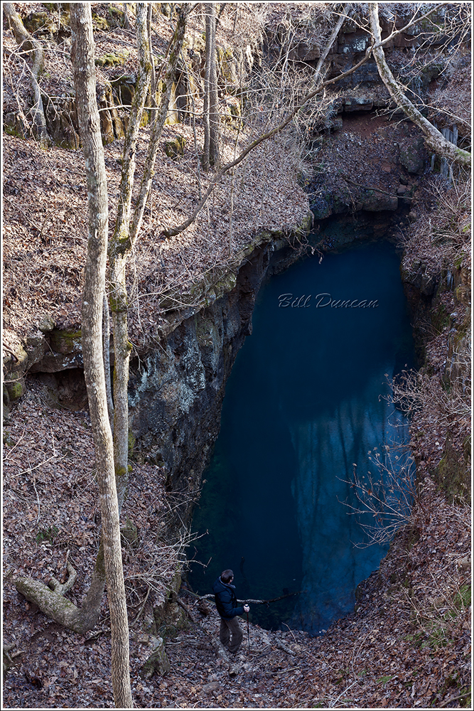
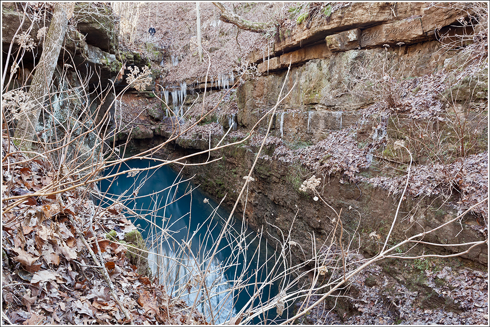
The Pinnacles, also known as “Boone County Pinnacles Youth Park” is a Missouri State Designated Natural Area located approximately 12 miles north of Columbia.  The geologic structures know as The Pinnacles formed between two parallel Ozark streams, Silver Fork and Rocky Fork.  These streams running closer and closer to one another have formed this erosional structure (senile ridge) that is approximately 75′ high and 1000′ in length.

Technical details: Canon EOS 7D camera, EF24-105mm f/4L IS USM lens @ 60mm, ISO 160,  f/13, 1/4 sec

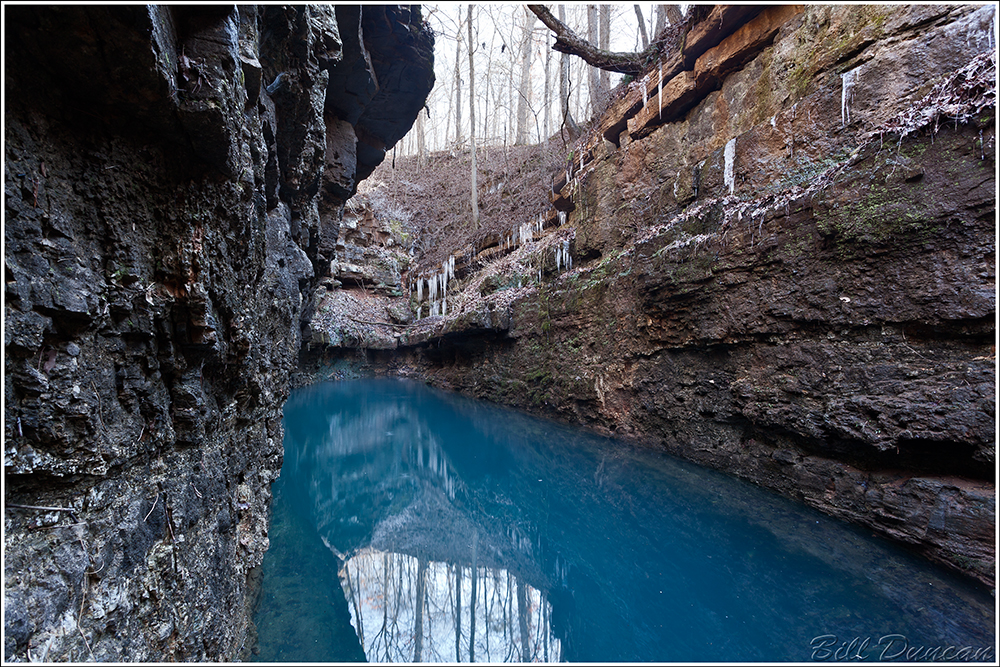
The Pinnacles are composed primarily of Burlington Limestone, with a small amount of sandstone to act as a “cement” in some places.  This fact was the inspiration of the title of this post.  These two streams are quite quickly, in a geological perspective, eroding this separation between them.  Limestones are very easily eroded by forces of weather and flowing water.  On this visit I easily found fossil crinoids in the rock, a feature Burlington limestone is known for.

Technical details: Canon EOS 7D camera, EF24-105mm f/4L IS USM lens @ 24mm, ISO 160,  f/18, 1/4 sec

The most recent time I visited here the weather was quite poor.  During one of the sporadic sleet and freezing rain showers I took shelter under one of the windows, or natural arches, that erosion has carved in the rock.  While I was waiting out the weather I was able to take a close look at the composing rock.  The amount of cracks and other signs of erosion was eye-opening.  While I was sitting there, bits and pieces of rock were literally falling off the overhanging arch and landing around me.  It takes little imagination to realize the effects that changing mid-western seasons along with ebbing flows of the streams are having on this feature.  Geologists reckon this rock feature has only a couple thousand years left, so if you plan on visiting, do it soon!

Technical details: Canon EOS 7D camera, EFS10-22mm f/3.5-4.5L IS USM lens @ 13mm, ISO 160,  f/16, HDR blend of two images

If you do plan on visiting and bushwhacking your way across the stream and up onto the rocks, take care!  There are numerous spots that one wrong step could potentially be your last.  On top of the risks of being swept away by high water in crossing the stream and falling from the top of one these spires, there is the usual risk associated with the Northern Missouri Ozarks – private property.  Apparently one side of this site is bounded by a stretch of property owned by a particularly cranky old man.  I was warned by a regular visitor to stay clear of that side of the park as he will not hesitate to accost hikers that stray too far.  Unfortunately one of the two shallow spots I have found to cross the stream is located in what seems to be his property.

Technical details: Canon EOS 7D camera, EF24-105mm f/4L IS USM lens @ 28mm, ISO 160,  f/16, 1/2 sec

The eastern red cedar, which is really a juniper, loves limestone.  This species is a long-lived pioneer invader that will be one of the first trees to grow in a disturbed area or any area that other species find undesirable.  Because it will grow in crevices along bluffs and shallow, rocky soils that often lack resources needed to grow quick and large, small trees can often be over 600 years old.  In fact, the oldest documented individual of this species was recorded in Missouri and was found to be 795 years old!  This species is currently taking over much of Missouri’s knob-top glades found throughout the Ozarks.  Cedar is not tolerant of fire and the suppression of natural and man-made fires on modern private land as well as public lands such as the Mark Twain National Forest is allowing cedars to take hold in these habitats where they were historically controlled.  But, this is a subject for another post.

Technical details: Canon EOS 50D camera, EF17-40mm f/4L IS USM lens @ 28mm, ISO 100,  f/16, HDR blend of four images

Just a stone’s throw south of The Pinnacles is a “shelving rock” style of shut-in (not pictured).  This feature was formed by erosional forces of Silver Fork as the creek runs dead-on into limestone bedrock and is forced to make a sharp left turn.  This shelter is 40′ deep, 10′ high and 125′ long.  Although it looks like the shelter is often flooded during high waters, I am sure this was used by pre-Colombian man.

The Pinnacles is another destination for the landscape photographer in the Missouri Ozarks that offers a diversity of photo ops depending on time of day, weather and the season.  It is also a high quality biological habitat even though it is so close to a a major metropolitan area.  With luck and continued proper management this location will continue to be a place visitors can come to appreciate the geologic and natural features that the Missouri Ozarks offers and once offered in much greater abundance.

Much of the information used in this post was found in “Geologic Wonders and Curiosities of Missouri” by Thomas R. Beveredge.  This is a highly prized book in my collection.  I only wish someone would update and revise with GPS coordinates!